 |
 Photo: Nant Maesglase towards Dinas Mawddwy |
History of the Cambrian Way - Origins of the Route
| Origins of the Route - a brief history by Tony Drake (from website 2006) |
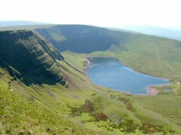 Llyn y Fan Fach from Bannau Sir Gaer The Carmarthen Vans |
The Cambrian Way was conceived by Tony Drake in 1968 and developed with help of a survey committee. The Countryside Commission was enthusiastic as to future designation as a national trail but there was much opposition from farmers, conservationists, mountaineers, the rural counties of Wales, and Snowdonia and Brecons Beacons national parks, whilst the Ramblers' Association and Youth Hostels Association strongly supported.
An officially designated national trail has to be on public rights of way. Much of the route proposed was across open moorland where access was permitted but was not actually a right of way as shown on the Ordnance Survey maps. The likely opposition from some landowners to creation of new rights of way and other factors influenced the Commission to abandon the project in 1982, following which Tony Drake produced a practical guide and handbook, following a line on public rights of way or where there was permissive or de facto access. Over 7000 copies have been sold and it is now at the sixth edition.
Since 1982 the Cambrian Way has been in a state of limbo, not merely that it is not a national trail, but is still officially opposed. Meanwhile, walkers who have tackled it have been ecstatic as to the experience, and some are at a loss what to do next.
When the Countryside Council for Wales (successors to the Countryside Commission) considered the Cambrian Way in 2000, it was decided that the time was not ripe, at least until the access to mountains and moorlands took effect. Other objections were said to be still valid, notably public safety and erosion. In 2001 the Foot and Mouth crisis highlighted the value of walking tourism to the economy of Wales. The access provisions of the Countryside and Rights of Way Act 2000 have meant that the public has a legal right of access to vast areas of Wales including all the sections of the Cambrian Way that were permissive or de facto access. All this means that there is a case for at least some recognition of the Way's existence, even if not as a National Trail with all its razzmatazz. Marking on Ordnance Survey maps at 1:25,000 scale will be sought, but walkers will still need the sketch maps in the guidebook. The Ramblers' Association strongly advocates recognition of the Cambrian Way. A.J. Drake (2006)
History of the Cambrian Way - Full History
| Full History of the Cambrian Way - by Tony Drake (from his guidebook 2008) |
Below is a detailed history of the Cambrian Way in Tony's own words (extracted from the 2008 guidebook). It must be noted that since this was written there has been a considerable improvement in the attitudes of many of those who were opposed to the Cambrian Way and the National Park Authorities and many County Coucils are now co-operating well with the Cambrian Way Trust. However, some County Councils, are still opposed to the walk, with Powys refusing point blank to allow any waymarking of the Cambrian Way throughout their area of jurisdiction. However, this is less of a problem than it may seem, as a large proportion of the route through Powys is within the Brecon Beacons National Park, where these issues are controlled by the National Park Authority. Also, as new generations start to influence decisions, the stance made in Powys may mellow.
Update November 2019: Powys have now agreed to waymarking! George Tod
My first involvement in long distance path planning was in the early 1950s when the Ramblers' Association in Gloucestershire did the initial planning for the Cotswold Way. About the same time I was involved in negotiations for amendments to the designated route for the Offa's Dyke Path in the Wye Valley. Between 1957 and 1960 I was involved in the planning of a serial walk along the Dyke path for the three Gloucestershire rambling clubs. These were very popular and when it was over the cry was "What can we do next?" I did some preliminary planning for a route from Gloucester to Snowdon via the Black Mountains, Brecon Beacons and Plynlimon. The enormous attraction of this mostly mountain route was apparent, but the Gloucestershire Ramblers did not take it up. It was not until 1967 that it occurred to me to wonder why no one had proposed a long distance route over the principal mountains of Wales. Soundings in the Ramblers' Association and the Youth Hostel Association circles in Wales brought an immediate and enthusiastic response. Both the RA and YHA passed motions at their respective national council meetings in March 1968 calling for the creation of a Cambrian Way Long Distance Footpath.
| Full History - The Cambrian Way Committee |
Roger Brickell, the South Wales RA secretary at that time, convened a meeting at Kington on June 23rd 1968 at which a Cambrian Way Committee was formed with myself as chairman and Roger as secretary. A predominantly high level mountain route was to be surveyed and various organisations undertook sections by counties. The southern part was divided between the RA, YHA, the Brecon Beacons Voluntary Wardens Association and the Pontypool Group of the RA. In the north the British Mountaineering Council was offered the Caernarvonshire section but turned out to be hostile to the whole concept. Subsequently the RA and YHA based in Liverpool joined forces, led by Bill Hall and Brian Steventon respectively, and surveyed all the northern half.
The survey methods varied considerably. In the south some of the committee, notably Bob Rowson and Keith Mascetti were already knowledgeable of their area. Denis Veasey, David Robinson and Don Sutor made surveys in the lesser known Elenydd area in Central Wales, and concluded that the western side of that wild area had fewer forestry problems. The Liverpool Ramblers and hostellers had different methods and descended on their allotted area by coach and dispersed into several survey groups. Although I had visited much of Wales, particularly on meets of the Gloucestershire Mountaineering Club, my roving commission on all sections took me to delightful parts of Wales I might never have visited.
My first proposal was for a route from Capel-y-ffin to Snowdon but this soon got extended in both directions. Capel-y-ffin was clearly no equivalent of Edale on the Pennine Way but proposals to start a little further south at Abergavenny did not satisfy the South Wales members of the committee, who devised a route from Cardiff skirting the coalfield. At the northern end the natural extension was to the North Wales coast and soon the attraction of the long ridge of the Carneddau and the idea of a coast to coast, castle to castle route, clinched Conwy as the northern terminus.
At the subsequent three meetings of the committee the difficulty of arriving at a consensus view increased and there was a temptation to suggest alternatives because of disagreement. However, certain alternatives were agreed upon for safety reasons, such as a lower level alternative to the Rhinog ridgeline, and the Pyg Track or Crib Goch on Snowdon.
One alternative never properly resolved was whether to go north from Plynlimon to CadaIr Idris via Machynlleth or the longer way via Dylife, Dinas Mawddwy and Maesglase. (See later in the guide for the main arguments.) There was considerable discussion over the Black Mountains, partly as to whether to include them, and, if so where to cross over to the Brecon Beacons. I never liked the variation proposed via Mynydd Llangorse and Talybont, because it omitted the very fine Pen Allt Mawr ridge and the Llangattock cave area. The Brecon Park wardens advocated use of the Brecon and Usk canal towpath from Llangattock and Talybont but I could never see keen mountain walkers wanting to walk nine miles of towpath, however attractive.
| Full History - The 1971 Proposals |
On July 10th 1971, after the ceremony at Knighton declaring the Offa's Dyke Path officially open, I handed John Cripps, chairman of the Countryside Commission, a set of maps giving mmittee's proposed route for Cambrian Way. In November that year I produced what I called the Interim Report and this lamentably was the only information on the Cambrian Way that I found time to produce until the first edition of this guidebook in 1984. Many hundreds of a scruffy 34 page duplicated report were sold to would be walkers until most of the stencils wore out.
The Countryside Commission had the responsibility for making recommendations to the Secretaries of State for the Environment or for Wales for the creation of long distance paths, (now called National Trails) under provisions of the National Parks & Access to the Countryside Act 1949. (Since 1991 these duties in Wales have been taken over by the Countryside Council for Wales). Routes approved by the Secretary of State become the responsibility of the local authorities to create with a 100% grant from national funds. New rights of way can be created by agreement or compulsorily by creation order. The Commission from the beginning made encouraging noises and first mentioned the Cambrian Way in its annual report for 1968. The Interim Report was well received but it was made clear that restricted resources would dictate only limited commitment to the proposals. This proved to be a considerable understatement, such that the Commission's next four annual reports only indicated that the route was "under consideration". It sought to get reactions from the likely user organisations before approaching local authority and landowning interests. The Committee for Wales of the Countryside Commission was enthusiastic both under the chairmanship of Dr. Margaret Davies and later of Trevor Lewis and James Kegie.
In April 1976 the Commission approved the Cambrian Way project in principle and in September 1977 started official consultations on the basis of a map showing both the Cambrian Way Committee's route and the Commission's Preferred Route which differed in many respects. All the principal summits in Snowdonia were omitted. The route was to go over the Arans [Garanod] and the Arenigs [Arenigau] instead of the Rhinogs [Rhinogau/Rhynogydd] and Cadair Idris. The crossover from Black Mountains to Brecon Beacons was to be via Mynydd Llangorse.
Following opposition from many quarters, the Commission issued another line in January 1980 called a Consultation Route. This time the Cambrian Way Committee's route was not shown on the map, though the new route was closer to it than the 1977 line. Snowdon was included but still not the ridge of the Carneddau, Cadair Idris was included and a route to the seaward side of the Rhinogau instead of a route over the Arans, where in the meantime an access row had blown up. The Black Mountains were omitted altogether following pressure from the national park authority.
There had been much criticism of lack of consultation by the Commission, so to meet this it had decided to appoint field officers to meet landowners and other authorities. The first field officer, John Tetlow, a lecturer of the Department of Town Planning at the University of Wales, was appointed for a year and asked to report on the southern section up to Llandovery. He started off full of enthusiasm and the right ideas but when confronted with the opposition of commoners' committees and the national park authority, came up with some extraordinary compromises. Neither Pen y Fan nor the Carmarthen Van summits were to be part of the route, Pen y Fan which had erosion problems on the obvious route, and the Vans because the commoners would only agree to a route creeping round the base of the common and through conifer woods. The Cnewr Estate would not agree to any access during the lambing period (April 15th to May 10th) and the Countryside Commission was not prepared to have a long distance path with such a limitation.
The second field officer to be appointed, Donald Hoare, a former principal of an outdoor pursuits centre in Wales, fared better than John Tetlow and found general acceptance of the Cambrian Way proposals in the central section.
After years of support for the project and considerable determination to see the Cambrian Way designated, the Countryside Commission suddenly caved in and, with regret, abandoned it in January 1982. It concluded that there was continuing and widespread opposition to the proposed route, even when alternatives were considered. It was one of the earliest major decisions of the Commission following the appointment of Derek (later Sir Derek) Barber as its new chairman and who was advised to abandon the project by Martin Fitton, then the Principal Welsh Officer of the Commission. The decision was seen as an act of appeasement to the Welsh farmers in the hope of more cooperation on other countryside issues.
Donald Hoare's contract was terminated and the Commission never got round to appointing a field officer for the northern section. Who knows what ghastly compromises he or she might have been forced into in the Snowdonia National Park?
| Full History - The Recreational Organisations |
The Ramblers (formerly The Ramblers' Association) has consistently supported the Cambrian Way concept. Its National Executive Committee approved the principle of a Cambrian Way following a meeting, which I attended in July 1972, but agreed that any guide on the subject should stress that it was a mountain route. It was proposed that the title should be "The Cambrian Mountain Way". In the late 80s support for the Cambrian Way was confirmed as the RA's preferred additional national trail in Wales. A Welsh coastal path was later added to its priority list. In 2006 the Welsh Council of the RA called for recognition of the Cambrian Way as at least recreational status.
The Youth Hostels Association likewise consistently supported the idea of a high level route with low level alternatives. It looked forward to an exciting new outlet for the energies of young travellers.
The British Mountaineering Council's North Wales Committee was bitterly opposed to the idea of a Cambrian Way and in particular to it going over the Rhinogau. At a meeting in February 1972, at which I was representing the Gloucestershire Mountaineering Club, only the London Mountaineering Club representative gave support. The BMC's South-west and Southern Committee, covering South Wales decided in favour so that the matter was called in nationally. I attended a meeting of the Committee of Management in October 1972 and after an hour and a half's debate Cambrian Way was approved by 11 votes to 4. Subsequently however the BMC Safety Committee secured a reversal of the decision on safety grounds, and thought that designation would "encourage peak baggers and merit badge enthusiasts into difficult and remote areas". The North Wales Committee was asked to work out an alternative to the Rhinogau and it was their route over the relatively dull Arenig Fawr and moorland to the south-east of Ffestiniog that appeared as part of the Countryside Commission's preferred route in 1977.
| Full History - The County Councils and the National Parks |
Numerically the county councils were equally divided as to the merits of a Cambrian Way. Gwent, South Glamorgan and Mid Glamorgan being in favour with Dyfed, Gwynedd and Powys against. Those against however controlled 87% of the proposed route.
Both of the national park authorities opposed the Cambrian Way. Brecon Beacons National Park claimed that the route proposed was neither logical nor in keeping with the policies of the national park plan. That plan defined the Carmarthen Vans as a remote and vulnerable area where additional recreational activity would not be encouraged by the provision of further facilities. The use of two further ridges of the Black Mountains for a long distance path was said to be difficult to accept and support. Despite the 100% grants available for national trails it was argued that concentration of limited resources on long distance paths reduced the amount of work carried out on the path network generally. It was pointed out that the cost of erosion work in the Brecon Beacons was falling entirely on the national park and the National Trust, but no mention was made that 100% grant could be available if the erosion was on an official national trail. The national park committee went to the length of passing a resolution in 1986 to ban the sales of this book from its Mountain Centre near Brecon. Attitudes have changed and sales are now permitted.
Snowdonia National Park in its national park plan (1977) said "The National Park Authority is not convinced of the desirability of the proposed Cambrian Way long distance footpath. In particular they are opposed to the suggested route linking more of the principal summits of Snowdonia. The Authority will therefore seek further discussions on the topic with the Countryside Commission and other interested bodies. They certainly had discussions with the Commission but not with the RA or YHA.
The Farming Interests Both the National Farmers Union and the Farmers Union of Wales were vociferous in their opposition to Cambrian Way and used their powerful lobby to influence the local authorities and park committees. The Country Landowners Association was apparently not opposed to the project.
| Full History - The Instant Cambrian Way |
The arguments raged furiously from 1968 to 1982 as to whether a Cambrian Way was desirable and if so where it should go. If the project had not been abandoned, the arguments would probably have gone on for decades and the end result, if any, would at best have been a set of miserable compromises.
It was becoming apparent, even before abandonment, that if the compromises being considered were adopted, there would have arisen the anomalous situation of Cambrian Way walkers watching others go the obvious well established ways while they were plodding round the edges of commons and missing the tops. Guidebooks would have appeared advocating different routes to the official line and the whole concept of national trails would have fallen into disrepute.
Following abandonment there was a freedom to choose any way over which the public has a right of way or access, or where there is permissive use. On commons and other open country it is reasonable to describe well used routes - there would have been no books on mountain walks in Wales if rights of way only had to be followed.
With hindsight it is perhaps a pity I did not produce a guidebook during the mid 70s but the need not to prejudice possible new rights of way was felt to be paramount. After abandonment, much further survey was carried out to make more use of existing rights of way. In the event I was "pipped at the post" by Richard Sale, whose "A Cambrian Way" was published in February 1984. Subtitled " A personal guide to an unofficial route", the book was not a practical guide and handbook as this book sets out to be, but has 270 pages packed with fascinating reading, mostly historical, and which makes excellent reading after a day on the Cambrian Way. Richard and I had several meetings to coordinate routes but we agreed to differ on some.
How can it be that the Cambrian Way, officially abandoned after much opposition, suddenly came into existence at the behest of Messrs Drake and Sale? Is it thought irresponsible to take advantage of the right of any citizen to suggest to others where they may walk? Some books have undoubtedly caused embarrassment where insufficient research has been carried out as to rights of way and as to possible impacts on wildlife and erosion problems. The public status of the routes in this guidebook has been the subject of all reasonable checks and has been made by one who has a background of 58 years experience in dealing with rights of way matters. The sections of the route over de facto access land on rural commons (10%) and other mountain and moorland (2�%) were carefully chosen to be along well established routes where even the most law abiding walker would not have felt it necessary to try to ascertain who the owner was and to ask permission to use.
Five editions of this book have been published between 1984 and 2000. About 7700 copies have been sold without, as far as I am aware, any dispute over rights of way or access: at least no problems have filtered back to me as author. There have been a few obstructions and maintenance problems, which have been reported to the appropriate highway authority.
None of the county councils have sought to designate the Cambrian Way as a recreational route or pressed for national trail status although Ceredigion has given priority to some major problems. The Countryside Council for Wales (CCW) actively sabotaged efforts to encourage use of the route by banning promotion by the Wales Tourist Board. In particular it banned the enterprising walking package offered by Nick Bointon, using transport and navigational aids, from Llanerchinda, near Llandovery. This enabled walkers to traverse the Brecon Beacons section and on into Central Wales. CCW disapproved of the televising of Janet Street-Porter?s walk. Welsh Minister, Peter Hain, openly criticised the CCW policy.
A meeting was held in April 2000, attended by representatives of CCW, RA and the rural counties involved, (but not the author of this guidebook), at which it was assumed by CCW that the counties and national parks still held to the policy of opposition agreed forty years previous. They appeared to ignore the promised access which would legalise the permissive access which had existed for years without dispute. Clearly designation of any kind should await legal access but there seemed to be an assumption that the highway authorities would not want to maintain the route.
| Full History - The Right to Roam |
For over a century there was a clamour for a right to roam over open country. Access to grouse moors in the north of England was the main bone of contention, particularly from the Ramblers' Association. Success came with the passing of the Countryside and Rights of Way Act 2000. Grouse shooting is not a problem in Wales so the effect of the act has been mainly to legalise the de facto access already enjoyed. Much of the Cambrian Way is over land where public use has been accepted, often with ladder stiles erected by the highway authority or warden service where fences crossed walkers' regular desired lines. Thus the principle objection to designation suddenly disappeared and gained legal public status, albeit with possible restrictions.
The Ramblers' Association Welsh Council in April 2006 passed a resolution calling for recognition of the Cambrian Way as following an existing high level challenging mountain route of great scenic beauty and that it is worthy of at least recreational path status. This brings the main history of the Cambrian Way up to 2008. A.J. Drake (2008)
History of the Cambrian Way - Tony Drake Obituary
| Obituary to Tony Drake MBE - 25/01/1923 to 07/03/2012 |
Written by Mavis Rear, Ramblers Association Gloucestershire Area Secretary and former Area Chairman - 21 March 2012
| Antony John Drake - Rambler Extraordinaire |
 |
When Tony told me that he would like me to deliver the address 'come the day', I agreed, secretly hoping that his well known attention to detail and insistence on accuracy, would include writing the script - but sadly he left that to me. That being the case, I shall endeavour tell you something about him, but with such a long and action packed life, I can at best, only skim the surface.
We remember Tony as a Rambler extraordinaire - as a man of passion with an enduring love of the countryside and of the great outdoors. We remember him too, as a great campaigner, who achieved so much and who inspired so many - to work with him, for access on foot, for the enjoyment of our glorious countryside.
Born on the 25 January 1923, Tony was the only child of Leslie and Gladys Drake.
He was educated at Pates Junior School and at Wycliffe College, Stroud. At Wycliffe he joined the Scouts and relished outdoor pursuits. The Wycliffe boys enjoyed a fair amount of freedom. At weekends they took ferry trips across the River Severn for expeditions to the then remote and industrialised Forest of Dean, with its coal mines and iron works. This was a very different Forest from the green and beautiful place which is so attractive to tourists today. He was on a school expedition to the Mediterranean when World War 2 was declared. The party, undaunted, carried on and completed the trip.
He left school at the age of 16 and entered the family business. Drakes was a significant department store, established in 1888, in Cheltenham by his grandfather. In order to train Tony for his intended ultimate role of proprietor of Drakes, he was sent to learn the business, starting at the bottom, at The Bon Marche, now Debenhams, in Gloucester. This business training seems to have been thorough because it stood Tony in good stead in his chosen role of RA Glos Area Footpath Secretary, where his record keeping was unparalleled.
At the age of 18 he volunteered to join the Royal Air Force. He trained as a radar technician and during this time he was posted to various far flung locations in Britain. He was demobbed in 1946.
From then until the 1970's he worked at Drakes - as 'Mr Antony'.
At some time, Tony took up Morris Dancing, which he often reminded us was for tough men doing strenuous warlike dancing, and in due course became Bag Man (the secretary). He played the accordian.
Like many others, he took walking holidays with Cooperative Holiday Association and Holiday Fellowship in England, and with Ramblers Holidays in Europe. Travel then was always something of an adventure.
Tony is first recorded as Footpath Secretary in 1951, at the age of 28. He held that role until his retirement in 2008, and even after that he continued as Area Footpath Consultant, finally retiring in December 2011 when he also gave up the post of Area President, which he had held since 2009.
Though working in the family business, his real interest was the countryside and walking. He was inspired by the passing of the National Parks and Access to the Countryside Act 1949 and the subsequent Acts which opened up opportunities for walkers and the creation of the Definitive Map. Tony and his teams of Ramblers volunteers were very heavily involved in survey work, and in recording the newly defined rights of way.
The creation of the Definitive Map really caught his imagination and he seems to have worked tirelessly on this - in the early days to the detriment of his business. He obtained copies of the 1:10,000 OS maps and organised teams of volunteers to mark up, in colour, the rights of way onto hundreds of maps - and he ensured that they were constantly kept up to date as new footpaths were registered. His maps, and his files, one for each of the over 200 parishes in Gloucestershire were transferred to Gloucestershire County Council Archives, according to his wishes, just one week before he died.
Tony inherited the business from his father in the early 1970s. He had long been more interested in the countryside than the business, although he continued running the family business for a few years. But times were changing and old established family firms were losing ground, to newer ways of retailing, so Tony did some calculations, then took the bold decision to sell up, to invest the proceeds and to live off his income - and to devote his time to the real love of his life - the Ramblers Association.
Tony was a major contributor to the creation of The Cotswold Way - the 100 mile walk, which he visualised as a cliff top walk along the Cotswold edge, with occasional descents down the escarpment, and back up again, in order to take in the beauties of the lovely villages along the Way.
Tony, with characteristic thoroughness, created a series of Cotswold Way maps, based on out of copyright OS maps, marking the route with stick-on dots, (using Lettraset), to create masters which he subsequently had printed and which sold in their thousands, as did copies of his other creation, the Cotswold Way Handbook and Accommodation Guide.
In May 2007, the Cotswold Way was officially inaugurated as a National Trail with Tony and his fellow creator, Cyril Trenfield of Avon Area, as guests of honour at the Stanway House celebratory event.
Tony was not only a walker, he was also a keen mountaineer who climbed extensively in the Alps. More easily accessible though, were the Welsh mountains, a not too distant drive from Gloucestershire.
In 1955 Tony became a founder member of the Gloucestershire Mountaineering Club. He played a major part in the club's acquisition and conversion of a terraced house in Deiniolen, in Snowdonia, for use as a 'Club Hut', a base for mountaineering activities in that area. He became Hut Manager for several years and later became Club President. During this period, the 1970s, he was accompanied by club members on many of the surveys from which he developed his proposals for the Cambrian Way.
He was a very active member of the Youth Hostel Association in Wales and when he disappeared from Gloucestershire at the weekends he could often be found with a paint brush or tools in his hand, hard at work enhancing the limited resources of the most rural hostels tucked away in mid Wales. He always had a preference for the simple hostels, where he could hark back to his Scouting days.
Perhaps his greatest creation was the Cambrian Way, a hugely imaginative and demanding project for mountain connoisseurs, a challenging 270 mile walk with an ascent of 61,540 feet, which goes over every bit of high ground between Cardiff and Conwy. Again, Tony created a guide book, with hand drawn maps and a detailed route description, a list of B&B accommodation and prefaced by a history of its creation. At his instigation, there is now a website for the Cambrian Way. He took particular interest in the YHA hostels along the Way and he regularly updated the framed maps in those hostels. For fun, he asked those who completed the Way to send him a post card of Conwy Castle. He was delighted to receive several each year.
He was ambivalent about the Cambrian Way as a national trail, but he was mindful of the need for action to ensure its long term future and he has made some provision for this.
Of lasting national importance was Tony's 'White Roads Campaign' These were the class 4, 5 and 6 roads, shown white on the OS maps as minor roads and which were often unmetalled, and hence vulnerable, at a time when government grants were being given for hedgerow removal in order to accommodate agricultural machinery of ever increasing size. It is largely thanks to Tony's dogged determination and persistence these ORPAs (other routes for public access) are now marked on OS maps, as green dots.
He served on the Ramblers board of trustees for 20 years and he finally stood down in 2000. At General Council that year, he was made an Honorary Life Member for services to the Association.
In 2001 he was awarded an MBE for Services to Public Rights of Way.
I sat with him quite a lot during the last couple of weeks of his life. Whilst sitting with him, I reflected on the positive impact of knowing him, and working very closely with him for 15 years, and the consequences that this had had on my life. I felt privileged to have known him and grateful for the opportunities which this had opened up for me, as it had for so many others.
Since he died I have thought a great deal about what made him so special. He was a quiet, courteous gentleman. He was at the very heart of Gloucestershire Ramblers with his quiet authority and his encyclopaedic knowledge of the county and its footpaths. He was someone who always seemed to know the answer. He was thorough and patient. He somehow drew the best out of people. He set very high standards and expected them from everyone else and somehow everyone responded by giving their best.
We shall miss him enormously, but he trained us well, set us standards and in our hearts we shall feel him with us as we carry on his great work.
We shall not see his like again, but we have his work to do and we shall do it - for him.
History of the Cambrian Way - Cambrian Way Trust
| Formation of the Cambrian Way Trust |
In a codicil to his will, Tony Drake appointed three of his friends as trustees to continue his work in developing and overseeing the Cambrian Way. With the exception of George Tod, they were unable to take up trusteeship so a new trust was formed by George Tod, Richard Tyler, Geoffrey Williams and Jessica Tyler in 2015. The copyright of the guide and the rights to the website were transferred to this Cambrian Way Trust. Its function has been to publish the guide and maintain the website (www.cambrianway.org.uk) but also to oversee the condition and maintenance of the Cambrian Way and to publicise it. This work has been carried out with the assistance of Ramblers groups and members and Cambrian Way officers, funded from the major legacy which Tony Drake gave to the Ramblers. The profile of the route has been raised over the past five years and it has been featured in a number of national publications, particularly the Ramblers' Walk magazine.
History of the Cambrian Way - A.J. Drake Guidebooks
| Support for A.J. Drake Guidebooks - 6th & 7th Editions |
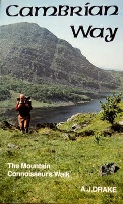
Cambrian Way - the Mountain Connoisseur's Walk
by A.J. Drake, �7.50, ISBN 978 1 5262 0046 4
Please note: Now that the new Cicerone guidebook has been launched, we are no longer permitted to sell the A.J. Drake guide due to our agreement with Cicerone.
There may, however, still be some copies of the A.J. Drake guide available through other outlets that have remaining stock.
We will still continue to provide support here for previous guidebooks.
 The guidebook (100 pages) - cover price of �7.50 was updated and published by the Cambrian Way Trust in 2016 but still attributed to A.J. Drake as author.
The guide was designed to be a compact, easy to carry, handbook full of practical information for planning and undertaking the walk. It contained a set of sketch maps of the route, including optional variants for access to accommodation, together with a general description of the route. A table of distances and ascents gave valuable help when planning each stage of the walk, as did the extensive list of accommodation addresses either on or close to the route, many of which are in remote areas and not widely advertised in other places.
In total, there were 106 sketch map sections, 85 B&B addresses, 11 Youth Hostels, 10 Bunkhouses and 25 camp sites in the guide. The book was 8" X 5" in size (the same width as folded OS maps). The maps and route description were on the middle pages, thus facilitating removal if desired.
The previous edition that is also supported here is the 6th edition published by Tony Drake himself in 2008.
History of the Cambrian Way - Updates to Old Guidebooks
| Updates to A.J. Drake Guidebook - 6th & 7th Editions |
Amendments to the 6th & 7th Editions of the A.J. Drake guidebook are available to download here. Later amendments were mainly issued as News items that are listed in the A.J. Drake News section below. The Cambrian Way News on the Home page has been started afresh and is intended for items relating to the Cicerone guide and route, but will contain items of a general nature as well.
Amendment Sheets (Guidebook 6th Edition)
The latest amendment sheet with or without the missing map can be obtained from the .pdf files below, which open in a new window. The map is intended to become page 97 of the guidebook. To print it at the correct size, ensure that Page Scaling: is set to None in the print dialogue box. The sheet can then be trimmed to 8" X 4.5" to affix into the back of the guidebook. More recent individual amendmants can be seen on the AJ Drake News section below.
1st Nov 2013 (.pdf files) - P97 Map and Amendments (78 kb) Amendments Only (37 kb)
Stage Planner Update (Guidebook 6th Edition)
Following a recent exercise of plotting the route using the Ordnance Survey's Getamap Service, some discrepancies have been found in figures shown in the Stage Planning section of the guidebook, as well as figures quoted in other places throughout the book. A further update has been carried out using 'OS Maps' online mapping using the route as defined in the 7th Edition of the guidebook. The ascent figures in this include undulations betweem plotted points and are considerably greater though likely to be more accurate. Please note that the walk has not got any harder, it is just that the measurements are more accurate! This should be kept in mind when comparing it with other walks that may not have been calculated in the same way. Amended Stage Planners can be obtained from the .pdf files below.
Stage Planner Update 3rd Feb 2012 (76 kb) Stage Planner Update 28th Jan 2016 (59 kb)
History of the Cambrian Way - A.J. Drake Guide GPX Files
| GPX Files - A.J. Drake Guidebook 7th Edition |
These files correspond to the A.J. Drake Guidebook 7th Edition. The Cicereone Guidebook has a number of route changes and any Cambrian Way Trail Marking encountered reflects the new routes.
Walking time is given using Naismith's Rule of 3mph plus 30mins per 1,000ft of ascent. Note; With a heavy pack and/or rough terrain plus rest breaks it is likely to take considerably longer. This is not an exact science and measurements have been rounded off.
Some GPS units will not accept routes with more then 250 waypoints, so split sections have been included with names ending in 'X' or 'Y' for larger files.
The following files can be downloaded and imported into the Ordnance Survey's OS Maps Service or into any other mapping software or GPS unit that supports this format. To download these files, just click each link. Internet Explorer may offer options to Open or Save but other browsers may just save the file. Files are normally saved in your Downloads folder unless another folder has been selected. Alternatively CambWayGPX.zip (last updated 13/08/2017) will download a zip file containing all the GPX files.
| GPX Files for A.J. Drake Guidebook 7thth Edition | ||||
| Section No. | Route | Download File | Updated | |
| 1 | Cardiff to Risca | CambWaySect1.gpx | 08/07/2016 | |
| Main Route - minor corrections added 08/07/2016 Distance: 18.0ml (28.9km) - Total Ascent: 2,600ft (793m) - Total Descent: 2,450ft (746m) - Time: 7hr 15min |
||||
| 2 | Risca to Abergavenny | CambWaySect2.gpx | 08/07/2016 | |
| Main Route - minor corrections added 08/07/2016 Distance: 20.5ml (33.0km) - Total Ascent: 3,800ft (1,160m) - Total Descent: 3,800ft (1,160m) - Time: 8hr 40min |
||||
| 2X | Risca to Pontypool | CambWaySect2X.gpx | 08/07/2016 | |
| First Part of Section 2 for GPS limited to 250 waypoints. Distance: 8.5ml (13.6km) - Total Ascent: 1,835ft (560m) - Total Descent: 1,640ft (500m) - Time: 3hr 42min |
||||
| 2Y | Pontypool to Abergavenny | CambWaySect2Y.gpx | 08/07/2016 | |
| Second Part of Section 2 for GPS limited to 250 waypoints. Distance: 12.0ml (19.4km) - Total Ascent: 1,965ft (599m) - Total Descent: 2,154ft (657m) - Time: 4hr 58min |
||||
| 3 | Abergavenny to Capel-y-ffin | CambWaySect3.gpx | 08/07/2016 | |
| Main Route - minor corrections added 08/07/2016 Distance: 13.4ml (21.6km) - Total Ascent: 3,690ft (1,125m) - Total Descent: 2,840ft (866m) - Time: 6hr 15min |
||||
| 3A | Accommodation Diversion to Llanthony | CambWaySect3A.gpx | 28/09/2012 | |
| Alternative route for accommodation Distance: 1.4ml (2.3km) - Total Ascent: 55ft (17m) - Total Descent: 960ft (293m) - Time: 0hr 29min |
||||
| 4 | Capel-y-ffin to Crickhowell | CambWaySect4.gpx | 08/07/2016 | |
| Main Route. The last half a mile to the summit of Twmpa is not clearly defined, though a number of faint tracks can be picked up along the way. Minor corrections added 08/07/2016. Distance: 16.3ml (26.2km) - Total Ascent: 3,055ft (931m) - Total Descent: 3,805ft (1,160m) - Time: 6hr 53min |
||||
| 4A | Accommodation Diversion to Pengenffordd | CambWaySect4A.gpx | 28/09/2012 | |
| Alternative route for accommodation Distance: 2.9ml (4.7km) - Total Ascent: 95ft (29m) - Total Descent: 1,520ft (464m) - Time: 1hr 0min |
||||
| 5 | Crickhowell to Storey Arms | CambWaySect5.gpx | 08/07/2016 | |
| Main Route. This is a very demanding section to complete in one day. A detour to Danywenallt Y.H. or Talybont-on-Usk is generally preferable. Several sections of the route are undefined, though paths can be picked up for most of the way. Updated to follow Beacons Way onto Craig Cwareli instead of crossing rough ground. Minor corrections added 08/07/2016. Distance: 21.0ml (33.7km) - Total Ascent: 6,020ft (1,835m) - Total Descent: 4,870ft (1,485m) - Time: 9hr 53min |
||||
| 5X | Crickhowell to Torpantau Pass | CambWaySect5X.gpx | 08/07/2016 | |
| First Part of Section 5 for GPS limited to 250 waypoints. Distance: 13.7ml (22.1km) - Total Ascent: 3,050ft (929m) - Total Descent: 1,950ft (929m) - Time: 6hr 4min |
||||
| 5Y | Torpantau Pass to Storey Arms | CambWaySect5Y.gpx | 08/07/2016 | |
| Second Part of Section 5 for GPS limited to 250 waypoints. Distance: 7.0ml (11.3km) - Total Ascent: 2,970ft (905m) - Total Descent: 2,920ft (891m) - Time: 3hr 49min |
||||
| 5A | Talybont Variant | CambWaySect5A.gpx | 28/09/2012 | |
| Alternative route for accommodation, either at Danywenallt Y.H. or in Talybont-on-Usk. Distance: 12.4ml (20.0km) - Total Ascent: 2,510ft (766m) - Total Descent: 1,630ft (498m) - Time: 5hr 22min |
||||
| 6 | Storey Arms to Llanddeusant (road crossing near Talsarn). | CambWaySect6.gpx | 08/07/2016 | |
| Main Route. Updated with minor changes by road crossing at SN853202. Further minor corrections added 08/07/2016. Distance: 16.3ml (26.2km) - Total Ascent: 4,305ft (1,312m) - Total Descent: 4,670ft (1,424m) - Time: 7hr 28min |
||||
| 6A | Llwyn-y-celyn Hostel Variant and Ystradfellte Variant | CambWaySect6A.gpx | 02/08/2015 | |
| Alternative routes for accommodation. Considerable sections of this route are undefined, though paths can be picked up in some parts. Alongside Ystradfellte Reservoir there are several tracks at different heights running in parallel. The lower ones have deep dips where they cross many small streams, whereas the ones higher up the hillside afford easier crossings. Updated to cross River Neath by old footbridge near Blaen-nedd-isaf Farm as shown in guidebook (no right of way to new footbridge through farm land and old footbridge has not been removed as previously thought). Distance: 19.0ml (30.6km) - Total Ascent: 4,435ft (1,352m) - Total Descent: 3,510ft (1,070m) - Time: 8hr 30min |
||||
| 6B | Llanddeusant Hostel Variant | CambWaySect6B.gpx | 08/07/2016 | |
| Alternative route for accommodation. Although this is an alternative route, it is highly recommended for the fine views of Llyn y Fan Fach, if time permits. Updated to follow Beacons Way from near Llyn y Fan Fach to Llanddeusant (disputed access on previous route). Further minor corrections added 08/07/2016. Distance: 5.0ml (8.0km) - Total Ascent: 165ft (50m) - Total Descent: 1,310ft (400m) - Time: 1hr 44min |
||||
| 6C | Sarn Helen Variant | CambWaySect6C.gpx | 08/06/2017 | |
| Alternative route following Roman Road. This route turns off the Main Route at Bryn Melyn to follow the old Roman Road of Sarn Helen, joining back up with Ystradfellte Variant near Blaen-nedd-isaf Farm, thus avoiding about 4 miles of rough walking, though not offering any accommodation. Distance: 4.0ml (6.4km) - Total Ascent: 320ft (98m) - Total Descent: 700ft (213m) - Time: 1hr 29min |
||||
| 7 | Llanddeusant (road crossing near Talsarn) to Rhandirmwyn | CambWaySect7.gpx | 08/07/2016 | |
| Main Route - minor corrections added 08/07/2016 Distance: 15.1ml (24.4km) - Total Ascent: 2,110ft (643m) - Total Descent: 2,825ft (861m) - Time: 6hr 4min |
||||
| 8 | Rhandirmwyn to Strata Florida | CambWaySect8.gpx | 08/07/2016 | |
| Main Route. Involves about 2 miles of difficult walking over rough and boggy ground beyond Ty'n-y-cornel Hostel. Route here is undefined, but keeping to higher ground helps to avoid bogs. Updated with diversion round Nant y Maen Farm. Further minor corrections added 08/07/2016. Distance: 19.2ml (31.0km) - Total Ascent: 3,360ft (1,024m) - Total Descent: 3,095ft (944m) - Time: 8hr 3min |
||||
| 8A | Soar y Mynydd Variant | CambWaySect8A.gpx | 28/09/2012 | |
| Alternative route. About half a mile longer but with easier walking (about 2.5 miles on minor road). Distance: 5.5ml (8.9km) - Total Ascent: 1,045ft (318m) - Total Descent: 620ft (188m) - Time: 2hr 20min |
||||
| 8B | Pontrhydfendigaid Variant | CambWaySect8B.gpx | 28/09/2012 | |
| Alternative route for accommodation. First 1.5 miles of route is undefined, though some faint paths can be picked up from time to time. Distance: 5.0ml (8.0km) - Total Ascent: 165ft (50m) - Total Descent: 1,310ft (400m) - Time: 1hr 44min |
||||
| 8C | Tregaron Variant | CambWaySect8C.gpx | 14/08/2011 | |
| Alternative route for accommodation. Distance: 5.0ml (8.0km) - Total Ascent: 140ft (43m) - Total Descent: 1,040ft (317m) - Time: 1hr 43min |
||||
| 9 | Strata Florida to Devil's Bridge | CambWaySect9.gpx | 08/07/2016 | |
| Main Route. Paths are now better defined, though boggy in places. Amended to avoid very boggy area towards Domen Milwen. Distance: 14.7ml (23.6km) - Total Ascent: 2,720ft (879m) - Total Descent: 2,660ft (812m) - Time: 6hr 13min |
||||
| 10 | Devil's Bridge to Dylife | CambWaySect10.gpx | 08/07/2016 | |
| Main Route. Some sections of route are not clearly defined, particularly that for about a mile from Source of Severn until track to Bugeilyn is picked up. Minor corrections added 08/07/2016. Distance: 19.8ml (31.9km) - Total Ascent: 4,325ft (1,317m) - Total Descent: 3805ft (1,160m) - Time: 8hr 42min |
||||
| 11 | Dylife to Commins Coch | CambWaySect11.gpx | 08/07/2016 | |
| Main Route. Some short sections are not clearly defined, particularly at the head of Cwm Ednant. Path from SN853983 to SN861987 now follows trcck on south side of fence. Other minor corrections added 08/07/2016. Distance: 9.5ml (15.3km) - Total Ascent: 1,840ft (561m) - Total Descent: 2,850ft (869m) - Time: 4hr 2min |
||||
| 12 | Commins Coch to Dinas Mawddwy | CambWaySect12.gpx | 08/07/2016 | |
| Main Route. Some sections of route are not clearly defined, particularly the right of way alongside the wind farm and also over hillside from SO873099 for about half a mile. Other minor corrections added 08/07/2016. Distance: 13.6ml (21.8km) - Total Ascent: 2,720ft (829m) - Total Descent: 2,610ft (795m) - Time: 5hr 50min |
||||
| 12A | Cemmaes Variant | CambWaySect12A.gpx | 08/07/2016 | |
| Alternative Route for accommodation. Minor corrections added 08/07/2016. Distance: 5.2ml (8.4km) - Total Ascent: 3,105ft (946m) - Total Descent: 1,130ft (344m) - Time: 3hr 13min |
||||
| 13 | Dinas Mawddwy to Barmouth | CambWaySect13.gpx | 13/08/2017 | |
| Main Route. This is a very demanding section to complete in one day and a detour for accommodation at Minffordd or King's Youth Hostel is generally preferred. Minor amendment made 25/8/2014 to avoid fences at Bwlch Llyn Bach. Further minor corrections added 08/07/2016 and 13/08/2017. Distance: 21.6ml (34.7km) - Total Ascent: 6,560ft (2,000m) - Total Descent: 6,845ft (2,086m) - Time: 10hr 20min |
||||
| 13X | Dinas Mawddwy to Bwlch Llyn Bach | CambWaySect13X.gpx | 13/08/2017 | |
| First Part of Section 13 for GPS limited to 250 waypoints. Distance: 9.0ml (14.5km) - Total Ascent: 3,470ft (1,039m) - Total Descent: 2,785ft (849m) - Time: 4hr 39min |
||||
| 13Y | Bwlch Llyn Bach to Barmouth | CambWaySect13Y.gpx | 08/07/2016 | |
| Second Part of Section 13 for GPS limited to 250 waypoints. Distance: 12.6ml (20.2km) - Total Ascent: 3,155ft (962m) - Total Descent: 4,090ft (1,247m) - Time: 5hr 41min |
||||
| 13A | Minffordd Alternative Route to Cadair Idris | CambWaySect13A.gpx | 13/08/2017 | |
| Alternative Route - either for accommodation or to take the more spectacular Minffordd Path to Cadair Idris. Minor amendments to show footpaths alongside A470. Distance: 5.2ml (8.4km) - Total Ascent: 3,105ft (946m) - Total Descent: 1,130ft (344m) - Time: 3hr 13min |
||||
| 13B | King's Hostel Variant | CambWaySect13B.gpx | 13/08/2017 | |
| Alternative route for accommodation - Footpath diversion round Ty'n Llidiart Farm. GPX file updated. Distance: 4.6ml (7.4km) - Total Ascent: 780ft (238m) - Total Descent: 1,835ft (559m) - Time: 1hr 53min |
||||
| 14 | Barmouth to Maentwrog | CambWaySect14.gpx | 13/08/2017 | |
| Main Route. This is a very demanding route and takes far longer than the mileage would suggest because of the difficult terrain, so few people can walk it in one day. Accommodation is scarce, generally involving a long detour west from Bwlch Drws Ardudwy - see guidebook for suggestions. The latest modification to the file results from recent evaluation of various routes on the ground. There are numerous alternatives, but this is one that avoids too many steep scrambles, though the difficult terrain makes some scrambling unavoidable. Minor corrections to route and to emphasise which side of wall to take towards Diffwys 13/08/2017. Distance: 24.6ml (39.6km) - Total Ascent: 8,345ft (2,544m) - Total Descent: 8,345ft (2,545m) - Time: 12hr 12min |
||||
| 14X | Barmouth to Bwlch Drws-Ardudwy | CambWaySect14X.gpx | 13/08/2017 | |
| First Part of Section 14 for GPS limited to 250 waypoints. Distance: 11.0ml (17.7km) - Total Ascent: 4,140ft (1,262m) - Total Descent: 3,155ft (962m) - Time: 5hr 40min |
||||
| 14Y | Bwlch Drws-Ardudwy to Maentwrog | CambWaySect14Y.gpx | 13/08/2017 | |
| Second Part of Section 14 for GPS limited to 250 waypoints. Distance: 13.6ml (21.4km) - Total Ascent: 3,985ft (1,214m) - Total Descent: 4,960ft (1,512m) - Time: 6hr 25min |
||||
| 14A | Rhinog Alternatives | CambWaySect14A.gpx | 28/09/2012 | |
| Alternative bad weather routes. These are provided through concerns about mountain safely in bad weather, allowing the most difficult parts of either half of the walk to be bypassed. Taking either of these involves missing a checkpoint. Distance: 12.1ml (19.4km) - Total Ascent: 1,175ft (358m) - Total Descent: 2,700ft (822m) - Time: 4hr 35min |
||||
| 14B | Trawsfynydd Variant | CambWaySect14B.gpx | 28/09/2012 | |
| Alternative route for accommodation Distance: 6.0ml (9.7km) - Total Ascent: 355ft (108m) - Total Descent: 495ft (151m) - Time: 2hr 10min |
||||
| 15 | Maentwrog to Beddgelert | CambWaySect15.gpx | 13/08/2017 | |
| Main Route. A few sections of the route are not clearly defined, but there are paths most of the way. Attemt to clarify route from Llyn Cwm-corsiog to ridge leading to Cnicht (still unclear in places). Distance: 13.8ml (22.2km) - Total Ascent: 4,335ft (1,321m) - Total Descent: 4,235ft (1,291m) - Time: 6hr 40min |
||||
| 15A | Bryn Gwynant Hostel Variant | CambWaySect15A.gpx | 13/08/2017 | |
| Alternative route for Youth Hostel only. This is seldom used, not easy to follow and obstructed in places, but has been updates as well as possible. Distance: 5.1ml (8.2km) - Total Ascent: 360ft (110m) - Total Descent: 2,085ft (635m) - Time: 1hr 51min |
||||
| 16 | Beddgelert to Pen y Pass | CambWaySect16.gpx | 25/08/2014 | |
| Main Route Some minor changes made to ascent of Snowdon 25/8/2014. Distance: 10.8ml (17.3km) - Total Ascent: 3,890ft (1,176m) - Total Descent: 2,840ft (866m) - Time: 5hr 27min |
||||
| 17 | Pen y Pass to Llyn Ogwen | CambWaySect17.gpx | 13/08/2017 | |
| Main Route. Parts of the route to Glyder Fawr are indistinct, but there is a path for most of the way. The rocky nature of the Glyderau means it is likely to take longer than the stated time. Minor corrections to route. Distance: 5.6ml (9.0km) - Total Ascent: 2,530ft (771m) - Total Descent: 2,725ft (831m) - Time: 3hr 3min |
||||
| 18 | Llyn Ogwen to Conwy | CambWaySect18.gpx | 13/08/2017 | |
| Main Route. This route is quite demanding, but is possible in one long day with the prospect of a rest at the end of the walk. Alternatively it can be broken with a detour to Rowen Youth Hostel. Updated route towards Sychnant Pass to match route intended in guidebook 08/06/2017. Distance: 19.3ml (31.1km) - Total Ascent: 5,325ft (1,622m) - Total Descent: 6,250ft (1,905m) - Time: 8hr 59min |
||||
| 18X | Llyn Ogwen to Bwlch y Ddeufaen | CambWaySect18X.gpx | 13/08/2017 | |
| First Part of Section 18 for GPS limited to 250 waypoints. Distance: 11.5ml (18.6km) - Total Ascent: 3,845ft (1,171m) - Total Descent: 3,440ft (1,048m) - Time: 5hr 41min |
||||
| 18Y | Bwlch y Ddeufaen to Conwy | CambWaySect18Y.gpx | 13/08/2017 | |
| Second Part of Section 18 for GPS limited to 250 waypoints. Distance: 7.8ml (12.6km) - Total Ascent: 1,390ft (423m) - Total Descent: 2,720ft (829m) - Time: 3hr 15min |
||||
| 18A | Rowen Hostel Variant | CambWaySect18A.gpx | 13/08/2017 | |
| Alternative route for Youth Hostel. This is the return route to the hostel leaving the main route at the eastern end of the Tal y Fan ridge and rejoining on a lower route to the old quarry. Minor corrections to route. To Hostel: Distance: 1.0ml (1.6km) - Total Ascent: 40ft (12m) - Total Descent: 1,095ft (334m) - Time: 21min From Hostel: Distance: 1.1ml (1.8km) - Total Ascent: 709ft (216m) - Total Descent: 115ft (31m) - Time: 43min |
||||
History of the Cambrian Way - Earlier News Items
| News Items - A.J. Drake Guidebook - 6th & 7th Editions |
Earlier News on the Cambrian Way relating to the A.J. Drake Guide
Please Note: The Cambrian Way News has been restarted with items relating to the Cicerone guide and any associated route changes on the Home page under News.
The Forum for Current Route Problems or Useful Hints and Tips
If you have come across any problems or obstructions or anything else that you think may be of value or interest to other walkers, or if you have an update to any item already posted, please e-mail webmaster@cambrianway.org.uk with details so that it can be posted here. Your name can be added if you wish, or you can remain anonymous with just your initials and town or country displayed. We are also keen to hear of any B&Bs, hostels, bunkhouses, camp sites etc that are not already in the guidebook, especially in remote areas where accommodation may be scarce.
| 35. Mountain Air Inn and Lamb Inn both now closed (Guidebook Map 3) (Tom Fisher) | 24/06/2018 |
| Tom reports that both the Mountain Air Inn and the Lamb Inn on the way to Pontypool are now closed. Previous editions of the guidebook have mentioned one or other being open or closed at various times but both are unlikely to re-open. |
| 34. Wild Camping on the Cambrian Way (Mike Greenleaf) | 12/06/2018 |
|
Mike completed a walk of the Cambrian Way at the beginning of June 2018 in the amazing time of 10.5 days, though he does say that the weather made the walking very hard in some places and a schedule of 12.5 days would have been easier. He was wild camping all the way, so could be flexible in between resupply points without needing to add extra distance to reach accommodation. He has provided a list of the wild camping places where he stayed as well as the resupply points he used. He did the walk in 2011 with his three children aged 15, 12 and 11 in 2011 in 20 days, also wild camping, and he has provided his schedule for that as well. These may be useful for anyone planning something similar.
Please note: Strictly speaking wild camping is only permitted with the landowner's permission and is generally not permitted on National Trust land. Local authorities also often have bylaws prohibiting it in many public areas. In practice, however, it is often unofficially accepted in remote places provided you are respectful of where you camp and leave no trace of having been there. This is an assessment of the general situation and is not to be taken to imply approval by The Cambrian Way Trust. George Tod |
| 33. Guidebook Amendment Sheets no longer issued (George Tod) | 04/04/2018 |
| With the wider use of the Internet, the printable amendment sheets to the 6th Edition of the guidebook are no longer being produced, though the one from 2013 which includes the missing map is still available. Amendments to the accommodation section of this website are updated whenever known and most accommodation providers have their own websites which can be checked for up-to-date details. Minor route changes, either corrections or improvements are incorporated into the downloadable GPX files from time to time and more significant changes are flagged on this CW News page. |
| 32. Ty'n-y-cornel and Dolgoch Independent Hostels (Guidebook 7th Edition p87 & p93, 6th Edition p84 & p90) (Bill Hine) | 04/04/2018 |
|
Please Note that Ty'n-y-cornel and Dolgoch Hostels, which are both owned by the Elenydd Wilderness Trust, no longer have any connection with the YHA and can no longer be booked via their website. Both are actually one star hostels (though the YHA only classedified them as bunkhouses) and can be booked either via the newly improved website at www.elenydd-hostels.co.uk/ or at the numbers given in the Accommodation Section. News: Ty'n Cornel Hostel (SN751534) and Dolgoch Hostel (SN806561) until 23rd March 2019: If you arrive to stay at either hostel on foot or by bike the warden will offer you a free 'Green Voucher' which entitles you to a return visit to either hostel at half price. |
| 31. Feedback from walks June 2016 and July 2017, GPX file updates etc. (George Tod) | 13/08/2017 |
| In June 2016 I walked from Cardiff to Barmouth and in July 2017 from Barmouth to Conwy, making a number of notes about various problems I encountered and also a few observations about minor diversions that may make the walk more interesting without adding to the distance. Part of the exercise was to put the GPX files from the website to the test by following them on the ground for the first time, with a view to improving their accuracy. I was hoping to have track logs of the complete walk, but found out that my GPS could only hold about five days worth of walks before filling its memory, even with the logging set to the minimum level. This meant that first nine days of logs of the first walk and the first two days of the second walk were lost, so I was only able to make adjustments to the GPX files for those based on notes and recollections and the accuracy may have suffered as a result, though they have been improved somewhat. However, working parties of Welsh Ramblers are surveying the route in more detail and feedback from this will be used to make further improvements. |
| 30. Problems finding Route round Gwernpwll on way to Rhandirmwyn (Guidebook Maps 21 & 21A) (George Tod) | 10/07/2016 |
|
There have been a few reports recently regarding the route around the buildings at Gwernpwll (SN782486) on the route towards the riverside path into Rhandirmwyn. Some walkers have been sent in the wrong direction, or have taken the wrong route by mistake, whilst one walker encountered a man who was gesticulating and speaking in a foreign language trying to get him to turn back to take the road route. This matter has been raised with Carmarthenshire County Council, as there seems to be a lot of cofusion as to the status of this track. The Ordnance Survey show it as a Byway Open to All Traffic (BOAT), which was its original status, but following severe erosion where it leaves the road at SN781421, it was closed to all but walkers and horse riders, and there is a notice to this effect. What appears to have happened is that Carmarthenshire County Council considered it to be closed completely on their maps and do not show it as a right of way, whereas the Ordnance Survey still show it as a BOAT. The result of this is that it has had no waymarking and, presumably the owners of the farm, which someone says now belongs to the local college, have taken this to mean the track is private. What adds to the confusion is that the actual track past the farm is obscured by trees until you get quite close, so it is easy to miss. I walked the route recently and found my way, mainly because I have walked the route before and know what to look for, though it still took me a while to be certain. At the far end of the second building, which is the long, narrow one on the left (furthest north), there is a lane going fairly steeply downhill amongst trees, so it appears that it might be private, but is actually the route in question. At the bottom of the hill is a farm gate on the left with no waymarking, but looking across the field a stile can be seen which leads to the riverside path followed by the Cambrian Way. Whilst on the subject of the this BOAT, it is worth mentioning that there is also some confusion where it descends from the road at the start. After the badly eroded section, it turns to the left as shown on maps, but towards the bottom of the slope it zigzags back again to the right and it is not obvious exactly where it goes. There is a footpath waymarked to the left but the BOAT goes through an unmarked, tied up gate with no waymarking, and just a sign saying 'Keep to the Edge of the Field'. However, although this is the official route, it is also the boggiest part of the field, so it is best to skirt around the bogs. Hopefully Carmarthenshire County Council will eventually resolve this issue and mark the route with appropriate signs, also informing the residents of Gwernpwll that this is a public right of way so they do not try to turn walkers away, but it may take some time for this to happen. Update 16/08/2017 - It has been reported by the local authority that the route has been waymarked and the college has been informed not to impede walkers using this route. August 2018 - We have had confirmation that the route through the buildings is clearly waymarked. However, the path to the river through the field at the bottom of the hill beyond the buildings is easy to miss. |
| 29. Snowdonia Slate Trail Project - Crosses Cambrian Way in two places (Aled Owen) | 07/07/2016 |
| This project, which has just succeeded in receiving funding, creates an 85 mile trail from Porth Penrhyn to Bethesda, through the Snowdonia slate villages. It crosses the Cambrian Way in two places, in Beddgelert and by Llyn Ogwen, so may be of interest to walkers who have spare time to explore extra parts of the slate mining heritage. |
| 28. Feedback from Warren Jones on his recent walk from Llandovery to Barmouth (Warren Jones) | 25/05/2016 |
This is a summary of useful comments from Warren's Email about the route and accommodation:
|
| 27. Blog of Walk by Malcolm Herbert (his website is no longer accessible) | 25/05/2016 |
|
Malcolm Herbert completed his walk on 20th May 2016 and wrote a detailed blog, but it is no longer available online.
George Tod |
| 26. Blog by Charles on his Walk of the Cambrian Way in Stages (Charles Hawes) | 11/05/2016 |
|
Charles Hawes is in the process of walking the Cambrian Way in short stages and is writing a blog of his experiences as he progresses. This is illustrated by some excellent photographs. George Tod |
| 25. Footbridge Closure at SH860149 near Dinas Mawddwy due to Storm Damage (Guidebook Map 34A) Now open again (Jacky Cross) | 03/04/2016 |
|
The footbridge at SH860149 was badly damaged by recent flooding and has been closed. Its re-instatement will be costly but the last I heard a considerable amount of the funding had already been secured and Gwynedd RoW team were hoping to be able to go ahead with the repairs. I don't know what the timescale is likely to be but in the meantime I think one would have to follow the roads to get into Dinas Mawddwy and not divert through the caravan park at all.
Update - Gwynedd Council have now replaced the bridge (April 2017) and the route has been reopened. |
| 24. Guidebook 6th & 7th Editions Snowdonia Area Amendments (Peter Rutherford) | 23/02/2016 |
The following points have been noted by Peter Rutherford (Access Officer - Snowdonia National Park Authority) in the 7th Edition Guidebook and they also apply to the 6th Edition.
|
| 23. Tafern y Garreg Inn now reopened (Guidebook 6th Edition Map 18A) (Alan Richards) | 16/10/2015 |
| Previous update sheets indicated that Tafarn y Garreg Public House was closed but it reopened in July 2015 (Guidebook 6th Edition P39 Map 18A) |
| 22. New Edition of Cambrian Way Guidebook to be published (7th Edition) (Updated 07/02/2016) (George Tod) | 04/10/2015 |
|
Stock of the 6th Edition of the Cambrian Way guidebook is running very low at the moment, though there may still be some available from some bookshops. The newly formed Cambrian Way Trust is in the process of updating the guidebook to produce the 7th Edition. Most of the updating has already been completed, and it is envisaged that this will be published later this year, although it is not possible to give a definite date at the moment. Details will be put here on the website as soon as stocks of the new edition are available. Update: We have news that the 7th Edition Guidebook has now been printed and should soon be on the way to the distributors. They take about one week to circulate it, so it should be available through normal suppliers by about the middle of February. If there are any problems in obtaining copies, please e-mail the Cambrian Way Trust at: info@cambrianway.org.uk |
| 21. Additional B&B at Brynawel, Rhandirmwyn (Jane Hand) | 23/09/2015 |
Jane Hand runs a B&B which is not listed in Edition 6 of the guidebook. The details are as follows:Address: Brynawel, Rhandirmwyn. SA20 0NS Cambrian Way walkers catered for - drying clothes and all emergencies! Could manage food supplies in advance or probably evening meal if we know in advance for very late/tired walkers. |
| 20. Ty'n-y-cornel Hostel Welcomes Walkers (Guidebook 6th Edition Map 22) (Bill Hine) | 19/09/2015 |
|
Ty'n Cornel has suffered from having its best walking and cycling routes officially 'closed' for 16 months with a marked turn down in overnight stays. The track has now been repaired and the gate is now unlocked. Please support us by visiting Tony Drake's memorial seat in his favourite valley and by staying at the hostel if you can. There is a small camping area where you can stay for �8 or a comfortable bed for �12. We are a charitable trust staffed and run entirely by volunteers so all the money goes back into the hostels. There is an emergency food cupboard so you won't go hungry.. You can book in advance with Richard and Janet on 01980 629259 all year round or take a chance and just turn up March to November when there are volunteer wardens. We are rarely full and we won't turn you away anyway. Call in and have a cup of tea or coffee anyway if you are passing. We are always looking for new volunteer wardens! Bill Hine, Trustee, Elenydd Wilderness Hostels, Hosteli Unigeddau'r Elenydd www.elenydd-hostels.co.uk/ |
| 19. Corrections to Route Down from Cadair Idris (Guidebook 6th Edition Maps 37 & 38A) (Richard Tyler) | 29/05/2015 |
|
Tony's statement on p.61 that the path crosses the Pony Path is incorrect as the Pony Path goes to the top of Cader Idris. It would be more accurate to state that one descends from Pen Cader down the Pony Path until the Pony Path turns right, at Ladder Style SH691135. The Cambrian Way Main Route goes straight on following the fence. There are further Ladder stiles at SH677135 and SH671130. Where the path turns right, the Grid Reference given on map 38A is wrong even after applying the previous correction from the correction sheet. A sign on the new Stile which has replaced the Ladder Stile states a grid reference of SH669127 which accorded with our own map reading. |
| 18. Obstructed Footpath Mynydd Ceiswyn (Guidebook 6th Edition Map 35) (Richard Tyler) | 29/05/2015 |
| For long sections on Map 35 Tony Drake's suggestions for which side of the fence to walk vary from what is on the ground, particularly when going up Mynydd Ceiswen where trees have made the route virtually impassable. In all cases it does not really matter as there are always clear paths on one side of the fences or the other and it is all open access land. |
| 17. Star Inn in Dylife has reopened with new owners (Richard Tyler) | 15/05/2015 |
|
Since the first news item below, the Star Inn has had another change of ownership. It has now reverted back to a local pub with rooms. The Star Inn, Dylife is a Star! Recently totally refurbished it provides a wonderful welcome and great beer and food with a splendid breakfast to send the walker off in the morning bearing packed lunches. |
| 16. Accommodation Problems in Abergavenny in September (Warren Jones) | 24/02/2015 |
| The Abergavenny Food Festival in September attracts a huge number of visitors, which can make finding accommodation anywhere around the area very difficult. The 2015 festival is on 19th and 20th September. |
| 15. Footpath Diversion round Nantymaen Farm (Guidebook 6th Edition Map 24 & 24A) (George Tod) | 24/02/2015 |
| For some time now there has been a legal footpath diversion in place around Nantymaen Farm and this is shown as the right of way on the latest O.S. maps. |
| 14. Route Change at Start of Watkin Path to Snowdon (Guidebook 6th Edition Map 44 & 45) (George Tod) | 04/12/2014 |
| It has been pointed out that the route at the start of the Watkin Path from Bethesda towards Snowdon has for some years taken a well signposted route through the trees from SH627505 rather than the right of way shown on even the most recent O.S. maps, which show it initially following the lane towards Hafod-y-llan. There is insufficient detail on the maps in the guidebook to notice this, but it is likely to be assumed that the right of way shown on the O.S. maps would be the route to take. The new path runs to the west of this, higher up the hillside through the trees and rejoins the original path at SH626512. |
| 13. Track Erosion near Ty'n-y-cornel Hostel (Guidebook 6th Edition Map 22) (Bill Hine) | 17/11/2014 |
|
Bill Hine of Elenydd Wilderness Hostels has reported problems of erosion on the route and a gate closure near Ty'n-y-cornel Hostel< Update 19/09/2015 - The track has now been repaired and the gate re-opened. Ty'n Cornel has suffered from having its best walking and cycling routes officially 'closed' for 16 months with a marked turn down in overnight stays. Please support us by visiting Tony Drake's memorial seat in his favourite valley and by staying at the hostel if you can. There is a small camping area where you can stay for �8 or a comfortable bed for �12. We are a charitable trust staffed and run entirely by volunteers so all the money goes back into the hostels. There is an emergency food cupboard so you won't go hungry.. You can book in advance with Richard and Janet on 01980 629259 all year round or take a chance and just turn up March to November when there are volunteer wardens. We are rarely full and we won't turn you away anyway. Call in and have a cup of tea or coffee anyway if you are passing. We are always looking for new volunteer wardens! Bill Hine, Trustee, Elenydd Wilderness Hostels, Hosteli Unigeddau'r Elenydd www.elenydd-hostels.co.uk/ From Bill Hine Half a mile east of Ty'n Cornel hostel, Ceredigion County Council has locked the gate to the ford and footbridge over the Doethie Fach. In December 2013 heavy rain washed out channels created by the 4x4s for about half a mile up the hill towards Soar y Mynydd chapel. Some of the damaged sections of the old road are over 2 metres deep and a metre wide and the sides are gradually collapsing. The Cambrian Way uses the road for about 250 metres from the bridle gate at SN757534 where the bridleway up the Doethie crosses the U1516 to the ford. The Council's sign says "Closed to all users" but the legal notice of 7th May 2014 prohibits "any vehicle from proceeding along the length of the road known as the U1516 between Ty'n-y-cornel and Soar y Mynydd..." so take care on that short section especially after dark. You will need to climb the gate. I am talking to the Ceredigion Rights of Way officer to see if we can have a style or diversion. I may come back to ask for your support on this. It seems unlikely that they will be able to afford to repair the track completely. Cambrian Way walkers always very welcome at Ty'n Cornel. Book with Richard on 01980 629259 |
| 12. Offer of Free Accommodation for Pathwork Volunteers (Alison Williamson) | 09/11/2014 |
|
Alison, one of a group of volunteer Rights of Way workers called Pathminders, based in Llanbrynmair (near Machynlleth), has made the following offer. If anyone wishes further information, please contact Alison at caemadog@gmail.com
From Alison Williamson Due to the generosity of one of our members we have the offer of the use, for RoW volunteer workers, of a holiday let in the quiet season. |
| 11. Overgrown Footpath near Commins Coch (Guidebook 6th Edition Map32B) - (Now Cleared) (Dave Hall) | 10/10/2013 |
|
This problem has kindly been reported by Dave Hall and has been reported by him to the Rights of Way Officer for Powys. This path used to run down the hillside through forestry and was one of the few places to have a waymark post erected by Tony Drake, as the path was easy to miss. However, in 2005 a large section of the forestry was clear felled of trees and has not since been replanted. This had the advantage of opening up wonderful views and also making the path plainly visible. Tony's original waymarker was lost in the felling operations but was later replaced by an official waymarking post. Since then the hillside has been left to go wild and the footpath has been neglected. An alternative route is shown on the map for use until this path is cleared. Update: This section of path has now been cleared by a group of Llanbrynmair Volunteers. Not only have they cleared it but they have erected signs at each end as well as at a junction in the middle. Many thanks. George Tod From Dave Hall My party walking the Cambrian Way on 10th October this year found this path almost completely overgrown, mainly brambles, which might have put off less determined walkers. The path position is approx 1/2 kilometre South East of Commin Coch. OS Explorer Map 215 1/25,000 Grid ref: OS SH 849025 South end of path. North end is GR.849026. We hope it can be cleared so others can enjoy the lovely Welsh countryside and not be put off walking in Wales. |
| 10. Obstruced Footpath near Dinas Mawddwy (Guidebook 6th Edition Map34 & 34A) (Dave Hall) | 11/10/2013 |
|
This problem has kindly been reported by Dave Hall. I also had problems here in 2010. A line of tightly packed conifers had been planted between the steeply sloping garden and the path. The path itself was obstructed by the lower branches of these plus brambles and other undergrowth. I managed to get through by walking on the garden side of the conifers and then reached the style by forcing my way with difficulty through the trees. The situation has, presumably deteriorated as the trees must have increased in size.
By the tone of the response from Gwynedd Council, it may be some while, if ever, before anything is done about this, so the only suggested option is to continue along the minor road until it meets the A470 main road. Double back along the main road for about 200 yards and resume the Cambrian Way along the access road/track to the left alongside the river. However, because of the diversion, this pleasant riverside route becomes about half a mile longer than the direct route along the A470 and minor road through the village, so a decision has to be taken as to whether it is worth the detour. From Dave Hall Just South of Dinas Mawddwy near Meirion Mill path was blocked by building materials from the nearby house "Delfryn" and as for as I could see by brambles so we kept to the road. Path from OS GR SH 858138 to 859139. I have reported to the Ramblers and The County Council. Reply from Gwynedd Council Rights of Way Team Leader Public Rights of Way in Gwynedd are Categorised according to their use and importance to the local community, with Category 1 paths being the most important and Category 4/5 being the least important. The particular path here is a Category 5 path, no doubt due to the fact that it terminates at the back of the former station platform, with no link through to any other highway or public right of way. Attempts to link it with the road network at Pont Minllyn in particular, have failed in the past. Currently this Unit only has sufficient resources to inspect and maintain the path network comprising Category 1 & 2 paths. Therefore I cannot guarantee that this path will be inspected in the near future, or that any great resource will be spent on the path. However, we are anxious that no new obstructions should become established. We will therefore endeavour to follow up your report in due course, and appropriate action taken as necessary. The landowner here is aware of the existence of the path, and he may merely require reminding of its presence to produce a satisfactory outcome. |
| 9. New Guidebook 6th Edition Updates Available for Downloading (Nov 2013) (George Tod) | 11/10/2013 |
| The latest set of Amendments to Edition 6 of the Cambrian Way Guidebook are available on the Guidebook page of the website under A.J. Drake Updates - (No longer applicable to newer guides). |
| 8. Temporary Footpath Closure near Arthog (Guidebook 6th Edition Map38) (JW-Bristol) | 27/06/2013 |
|
This is no longer applicable as the work has finished. This official closure is detailed on the Snowdonia National Park Website and is scheduled to last for approximately 6 months from March 2013. These are JW's comments about the closure: George Tod
We found a potentially dangerous problem earlier on where the local authority has blocked a path quite unnecessarily in my groups view. This is on the approach to Barmouth. The said authority appears to have taken leave of its senses! The problem occurs at the foot of the path by Arthog waterfalls. Maps 38 & 38b opposite page 63 have the details. The route does a dog leg left /right past a small church. The kissing gate is currently zip tied shut with a sign saying the path is closed (no duration is given) while flood defence work is completed on the estuary. The sign is hard to read as it a long "reach" beyond the locked gate. It actually admits there is "no suitable alternative" available. Since retracing ones steps is hardly an option the only thing to do is walk down the busy A493 for approx 1km before a bridleway is reached on your right which takes you to the estuary bank. There are a few issues here.
|
| 7. Clarification of Route up Rhinog Fawr (Guidebook 6th Edition p63) (JW-Bristol) | 27/06/2013 |
|
John has provided this description of the rather elusive route indicated by the Guidebook 6th Edition. I have, by looking at aerial photographs, attempted to show this on the map alongside the alternative route that I have used and included in the Section 14 GPX File provided for downloading. Update:- Please note that the GPX file for Section 14 has now been amended to follow the original route specified in the guidebook. George Tod I believe I can help with the route up Rhinog Fawr from Bwlch Drws Ardudwy. The 6th edition on page 65 first para attempts to describe the route and I found it somewhat misleading. This may be due to passage of time as new paths appear on the ground. The guide says the path is just beyond the wall (east side) at the pass at SH664282. Assuming you have just come from Rhinog Fach things are now rather easier than suggested. In what was poor visibility I found a near perfect route as follows:-
|
| 6. New Guidebook 6th Edition Updates Available for Downloading (Mar 2013) (George Tod) | 27/03/2013 |
| The latest set of Amendments to Edition 6 of the Cambrian Way Guidebook 6th Edition are available on the Maps page of the website under A.J. Drake Updates. There is also an updated Stage Planner (Pages 78 and 79 of Guidebook 6th Edition), which gives more accurate and consistent distances calculated from routes plotted using online mapping. GPX Files of the plotted routes are available via a link on the Maps page under GPX File (Old Route). |
| 5. Llanelli Ramblers tackle the spectacular Cambrian Way in celebration of Tony Drake MBE (Updated 20/10/2015) (Llanelli Ramblers) | 27/09/2012 |
|
The Llanelli Ramblers are celebrating the dramatic coast to coast walk that makes up the Cambrian Way, devised by walker, mountaineer and writer Tony Drake MBE, who sadly passed away earlier this year. To honour Tony's impressive contribution to the outdoor movement - which included over 60 years as a volunteer with the Ramblers to protect and enhance footpaths and trails - the Lanelli Group of Ramblers Cymru will be taking on the challenging 270 mile route in stages as part of their walks programme over the next year (2013). The walk was finally completed on Sunday 28th June 2015. Read the Report by John Maudsley (Walk Programme Secretary). |
| 4. Correction - New Footbridge 400m North at Blaen-nedd-isaf (Guidebook 6th Edition Map 17B) (George Tod) | 2010 |
| Correction to earlier GPX file - A new footbridge has been built at SN911148, where the Beacons Way crosses the River Nedd Fechan, (still marked in 2015 on O.S. maps as a ford). The footbridge at Blaen-nedd-isaf SN911144 still remains for those using the Ystadfellte alternative, but the new bridge can be used by those taking the Sarn Helen Alternative by joining the Beacons Way at SN913150. The main route is not affected. |
| 3. Route Diversion round Cefn yr Allt Uchaf Farm (Guidebook 6th Edition Map 20B) (George Tod) | 2010 |
| The Guidebook 6th Edition shows the route going through the farmyard of Cefn-yr-allt-uchaf Farm at SN769331 on the way to Llandovery. The farm is now unoccupied, with gates barring the entrance, but the diverted route is shown correctly on the latest OS maps, going to the west of the farm buildings. |
| 2. Route Diversion round Tyncwm Farm (Guidebook 6th Edition Map 26) (George Tod) | 2010 |
| There is a legal diversion in place which bypasses Tyncwm Farm on the route from Strata Florida Abbey to Teifi Pools. Unfortunately, the right of way shown on OS maps (2013) does not show the correct position of the path, which is clearly signposted from SN769656 with a new footbridge at SN772658. It rejoins the route at SN773658. |
| 1. Route Correction near Cefn Rhuddan Farm (Guidebook 6th Edition Map 20B) (George Tod) | 2010 |
| A legal diversion was put in place prior to Edition 6 of the guidebook because of a disputed right-of-way along the lane following the bottom of the valley. However, the route shown in the Guidebook 6th Edition goes up the farm track, close to Cefn Rhuddan Farm before joining the high lane going north, whereas the correct waymarked route is as shown on latest OS maps. This runs along the bottom of the field for about 100m before turning westwards up the hillside at SN763321 to join the high lane just north of the farm at SN762321. |