 |
 Photo: Sugar Loaf and Skirrid from Pen Cerrig-calch |
Route of the Cambrian Way - Southern Section
| Cardiff to Llandovery: 112 miles (180km), 22,515 feet of ascent (6,860m) |
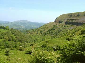 Sugar Loaf from the Llangattock Escarpment |
The way out of Cardiff is mostly through pleasant parkland alongside the River Taff. From the picturesque mock castle of Castell Coch, forestry and pleasant ridge walking takes the walker quickly across two industrial valleys before joining the open common ridges bordering on the Vale of Usk. The Brecon Beacons National Park is entered just north of Pontypool and open moorland followed to the Blorenge, thence by steep descent to the town of Abergavenny. After ascending Sugar Loaf a horseshoe shaped route follows the finest ridges of the Black Mountains via Capel y Ffin to Crickhowell. Thence follows an east to west traverse of the wild moorlands of the Brecon Beacons including Pen y Fan, the highest point in South Wales at 886m (2906ft.). The moorland continues to the Black Mountain, also known as the Carmarthen Vans, the largest common in Wales, before dropping to Llanddeusant (Youth Hostel) and field country to Llandovery with its railhead on the Heart of Wales line (Swansea to Shrewsbury). Allow nine days. Do not omit the first three days to Abergavenny and regret it later when you've got to Conwy. Most walkers do too much in the early days of a walking holiday. An extra day is worthwhile to explore the waterfall country at Ystradfellte.
Running on a roughly parallel lower level alternative route through the Brecon Beacons National Park is the Beacons Way, opened at considerable expense in 2005 by the Park and the Brecon Beacons Park Society (www.breconbeaconsparksociety.org/). From Abergavenny to Llangadog it is similar in distance to the Cambrian Way but involves over 3000ft more of ascent than the Cambrian Way from Abergavenny to Llandovery, due to its switchback routing. The Mountain Connoisseur will opt for the wide open spaces and spectacular route of the Cambrian Way.
Route of the Cambrian Way - Central Section
| Central Section - The Cambrian Mountains: 83 miles(133km), 14,895ft ascent (4,540m) |
 Photo: Bryn Bras from near Ystumtuen |
 Summit of Garn Gron |
The most frequent comments from walkers is how amazed they were with the beauty and remoteness of the central section, from Llandovery to Dinas Mawddwy. Back in 1972 the Countryside Commission tried to designate the area as the Cambrian Mountains National Park but the Secretary of State for Wales rejected the proposal without even a public inquiry. With hindsight it would probably have got through as an 'Area of Outstanding Natural Beauty' which gives much of the protection given to national parks. Recently formed is the Cambrian Mountains Society (www.cambrian-mountains.co.uk/) which is seeking AONB status to give more protection to the area from undesirable development including an excess of wind turbines.
The route follows the attractive Towy valley at Rhandirmwyn where it is difficult to imagine this was once a busy metal mining area. Even more attractive is the remote path up the Doethie valley leading to Ty'n y Cornel Youth Hostel, the most isolated hostel in Wales, saved from closure by benefactors who have bought the hostel, and by the formation of a charitable trust, Elenydd Wilderness Hostels (www.elenydd-hostels.co.uk/), to service it as a franchise hostel of the YHA. The route follows the western side of the wild moorland and forest area known as the Elenydd, which includes the gathering grounds of the Birmingham reservoirs. After superb rambling country around Devil's Bridge and Ponterwyd, the route crosses the uninhabited land mass of Plynlimon, with opportunities to view the sources of the Severn and Wye. The hamlet of Dylife once the workplace of 2000 miners, now only has a few houses, including, crucially, the Star Inn, which accommodates Glyndwr's Way as well as Cambrian Way walkers. A mixture of forest and sheep grazing land brings one through the windfarm on Mynydd Cemmaes and so to Mallwyd and Dinas Mawddwy.
Route of the Cambrian Way - Northern Section
| Northern Section - Snowdonia National Park: 88miles (142km), 27,711ft ascent (8,446m) |
 Photo: Moel Ysgyfarnogod & Foel Penolau |
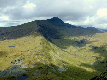 The Bwlch Main ridge to Snowdon Summit |
From the idyllic mountain enclosed village of Dinas Mawddwy a westward line is taken on a spectacular cliff top route via Cribin and Waun Oer before mounting the important and dramatic summit of Cadair Idris. Descent is made to the resort of Barmouth via the Cregenen lakes and the path alongside the railway on the Barmouth Bridge.
The Rhinog Mountains are the most controversial section of the whole route mainly due to the rough scrambling required in the adventurous central section. Barmouth to Maentwrog is 22 miles but progress is slow and there is no accommodation without considerable detour to Llanbedr or Trawsfynydd.
The new edition of the guidebook offers lower level alternative routes in deference to opposition to the main route.
Moelwyn Mawr is ascended before a difficult navigation exercise across to Cnicht. The ascent of Snowdon is by the lower reaches of the Watkin Path, thence by the Bwlch Main ridge to the normally clouded and crowded summit. The �9milllion scheme to rebuild the summit buildings is due to open later in 2008. (see www.snowdon-summit.co.uk/). The Pyg track is followed to Pen-y-pass and over the Glyderau to Ogwen, thence via the east approach of Pen yr Ole Wen to the Carneddau, entailing 4� miles at over 3000 feet (likely to be in cloud). The magnificent finish to the Cambrian Way drops down to 2000 feet at Tal y Fan before the final descent from Conwy Mountain to the end of the Mountain Connoisseur's Walk at Conwy Castle.
Route of the Cambrian Way - Route Changes for Cicerone Guide
| Route Changes for Cicerone Guide - Background, Stages, Details |
| Background to the Changes |
Following Tony Drake's death in 2012, The Ramblers among others received a legacy to be used for maintaining and promoting the Cambrian Way. To this end, working parties were set up in each region to survey the route with the purpose of establishing any repairs that were needed and assessing what trail marking could be implemented. In the process of doing this a number of suggestions for improvements were put forward, either to rationalise existing options, remove sections of road walking or follow more attractive routes. In seeking cooperation with National Parks Authorities, issues were raised about rights of way, mountain safety and bad weather alternatives, particularly in the Rhinog mountains. The rights of way issues proved largely to be due to inaccurate mapping rather than the route itself, but the other matters remained. A number of proposals were put forward by the Snowdonia NPA and these have been incorporated either in total or in part. All these are included in the forthcoming Cicerone guide and GPX files will be made available for download both here and on Cicerone's own website.
Please note that trail marking of the route has now commenced and this follows the new route. If you are following the Tony Drake guidebook, do not get confused if there are trail marks following a different route in some places.
| Route Stages - Details of the 21 Stages |
The route has now been split into 21 Stages, each one aimed at being possible in one day. However, this makes a few into very long days, so many people may wish to split them up. They are:
| Route Stages of Cicerone Guide | ||
| 1 | Cardiff to Machen | 15.2 miles (24.4km) |
| 2 | Machen to Pontyool | 11.6 miles (18.7km) |
| 3 | Pontypool to Abergavenny | 12.3 miles (19.8km) |
| 4 | Abergavenny to Capel-y-ffin | 13.3 miles (21.4km) |
| 5 | Capel-y-ffin to Crickhowell | 16.5 miles (26.5km) |
| 6 | Crickhowell to Storey Arms | 20.8 miles (33.5km) |
| 7 | Storey Arms to Glyntawe | 11.8 miles (18.9km) |
| 8 | Glyntawe to Llandovery | 18.4 miles (29.7km) |
| 9 | Llandovery to Ty'n-y-cornel | 16.1 miles (26km) |
| 10 | Ty'n-y-cornel to Claerddu | 14.6 miles (23.4km) |
| 11 | Claerddu to Ponterwyd | 14.8 miles (23.7km) |
| 12 | Ponterwyd to Dylife | 14.8 miles (23.7km) |
| 13 | Dylife to Dinas Mawddwy | 23 miles (37km) |
| 14 | Dinas Mawddwy to Bwlch Llyn Bach | 9.6 miles (15.4km) |
| 15 | Bwlch Llyn Bach to Barmouth | 12.4 miles (19.9km) |
| 16 | Barmouth to Cwm Bychan | 14.1 miles (22.7km) |
| 16/17A | Bwlch y Rhiwgyr to Moelfryn (Bad weather option) | 17.4 miles (28km) |
| 17 | Cwm Bychan to Maentwrog | 9.8 miles (15.8km) |
| 18 | Maentwrog to Beddgelert | 13.7 miles (22km) |
| 19 | Beddgelert to Pen y Pass | 10.8 miles (17.3km) |
| 20 | Pen y Pass to Llyn Ogwen | 5.4 miles (8.6km) |
| 21 | Llyn Ogwen to Conwy | 19 miles (30.5km) |
| Total | Main Route | 298 miles (479km) |
|---|---|---|
| Route Change Details - excluding minor changes and options |
| Stage No | From | To | Description |
| 1 | ST162783 /// brings. |
ST142800 /// empire. |
Crossing to west bank of River Taff to visit Llandaff Cathedral and returning to east bank via walkway on railway bridge to Whitchurch. |
| 2 | ST264973 /// rounds. |
ST275979 /// arrow. |
A better track with better views through Braen Bran community Woodland running parallel to previous route. |
| 2 | ST264960 /// chill. |
ST267967 /// pills. |
An easier descent from Mynydd Maen by looping further north. |
| 2 | ST264973 /// among. |
ST275979 /// arrow. |
A better track with better views through Braen Bran community Woodland running parallel to previous route. |
| 3 | SO291005 /// dared. |
SO294011 /// face. |
A detour through Pontypool Park, under the dry ski slope and up to the Shell Grotto (this was optional in the previous guidebook). |
| 3 | SO281122 /// wings. |
SO281126 /// blemishes. |
Descent of Blorenge via a more well worn path going east then northwest to Cwm Craf. |
| 5 | SO250319 /// shirts. |
SO225350 /// resting. |
Ascent of Twmpa (Lord Hereford's Knob) along the ridge of Darren Lwyd (the old YHA route). |
| 5 | SO225208 /// crypt. |
SO225208 /// crypt. |
A circular route around the top of Table Mountain added, returning to the same point. |
| 7 | SN883186 /// tent. |
SN861157 /// digests. |
Main route is now the Cnewr route as far as Fan Gyhirych, then descends southwest to join the Ystradfellte/Sarn Helen route near Penwyllt quarry into Glyntawe. The Ystradfellte and Sarn Helen alternatives have been dropped because of the limited accommodation available, though the alternative checkpoint at Ystradfellte remains for anyone wishing to take that route. |
| 8 | SN847167 /// urgent. |
SN828214 /// fried. |
The old Ystradfellte route is now the main route from Glyntawe to Bwlch Gledd via Fan Hir. |
| 8 | SN816217 /// cities. |
SN797219 /// tags. |
The main route now follows the Llanddeusant alternative to the west of Llyn a Fan Fach for better views and hostel accommodation. The direct route going northwest has been dropped. |
| 8 | SN797219 /// tags. |
SN787263 /// collect. |
The Beacons Way route is taken followed by a short path to avoid some road walking on the way to Llanddeusant. The old hostel alternative route is then taken to join the minor road 900m east of Talsarn. The route going down to Llyn y Fan Fach and along the waterworks access road to Llanddeusant is retained as a more sheltered alternative. |
| 13 | SH862055 /// actor. |
SH864062 /// lungs. |
The diamond shaped wood with no way through is now avoided by following the wind farm access road up to the eastern tip of the wood then following a contour through access land to rejoin the old route near the top of the hillside. |
| 13 | SH857122 /// squabbles. |
SH859144 /// estimated. |
From Pont Mallwyd, to avoid road walking, a route is taken along the hillside to the quarries west of Minllyn where there is a new alternative checkpoint that allows walkers to continue directly to Bwlch Siglen if they do not need to visit Dinas Mawddwy. Access to Dinas Mawddwy is down a path through the woods to rejoin the main A470 road south of the village. |
| 14 | SH859149 /// liver. |
SH836137 /// fled. |
The route from Dinas Mawddwy to Bwlch Siglen now takes a route through the quarry west of Minllyn where there is an alternative checkpoint. It then follows the ridge of Waun Fach to Foel Dinas and hence to Bwlch Siglen, with the option to bypass Dinas Mawddwy if none of the facilities are required. |
| 16 | SH619160 /// washed. |
SH622176 /// painter. |
The route from Barmouth to Bwlch y Llan follows the ridge rather than going past Bunkorama bunkhouse and the wireless mast. This is more direct and affords better views. |
| 16 | SH665270 /// headrest. |
SH664282 /// ruffling. |
From the summit of Rhinog Fach the route takes a direct path north which has recently developed to reach Bwlch Drws-Ardudwy without having to backtrack to Llyn Hywel and skirting round west of Rhinog Fach. |
| 19 | SH621520 /// promotes. |
SH606521 /// repeats. |
From the Watkin path up Snowdon, instead of continuing past the Gladstone Rock, the route heads west up the hillside to Bwlch Cwm Llan. This route is being promoted by SNPA and pathwork improvements have been made. The Gladstone Rock is now an optional detour. |
Route of the Cambrian Way - Planning to walk the Cambrian Way
| Planning a Walk - route finding, accommodation, weather, emergencies |
| Route Finding - GPS, Mobile Phones, Reading Maps, Daily Mileage |
Although there is now some Cambrian Way trail marking, this is mainly confined to farmland and low lying areas, so it must be stressed that the Cambrian Way is still largely unwaymarked and that the walker has to be able to navigate by map reading. Experience in interpretation of contours is crucial and a compass is also needed. However, the most useful modern device is a GPS navigation aid which will not only tell you exactly where you are, but can also hold GPX files of the route which can be followed, taking much of the effort out of route finding in all weather conditions. Of course, this does depend on battery power, so it is still important to know how to use a map and compass. In an emergency, mobile phones are generally useless, particularly in the valleys, though they can often pick up a signal on mountaintops where there is a clear line of sight, even if the nearest mast is several miles away. In remote areas phone boxes are generally being phased out through lack of use, though there are still a few around.
Do not make the Cambrian Way your first long distance walk but try other challenging routes and try navigating away from paths on open access land. Make sure you have waterproof clothing and that your boots will keep your feet dry and blister free.
A reasonably strong and fit walker can cover the distance in about 20 days. By comparison the Pennine Way is 25 miles shorter and involves only half the ascent required for the Cambrian Way, with average time of 19 days. Many choose to split the route into three, such as Cardiff to Llandovery in 9 days, the Central section to Dinas Mawddwy in 6� days and the Snowdonia section in 8 days. The clear message that comes through the valuable reports that come back is that the route was tougher than expected and that the enjoyment was dependant on the weather more than anything else. The Welsh mountains have several times as much rain as southern England.
| Finding Accommodation - Hotels, B&B, Hostels, Bunkhouses, Camping |
The guidebook lists places where you can spend the night close to the route but for more detail and up-to-date information, these are now shown on the Accommodation page of the website. Entry in the book is free and at the discretion of the Cambrian Way Trust. Tourist Board certification is not insisted upon. Most establishments were visited by Tony Drake and nearly half were stayed at overnight by him but in recent years a number of others have been added without necessarily being visited. The Cambrian Way Trust takes no responsibility for the information provided or for the standard of accommodation or other services provided.
There are 8 YHA hostels on or close to the way as well as a growing number of independent hostels and bunkhouses. YHA has had to capitalise on its property values so many hostels have closed or are being run by other organisations, sometimes with YHA booking facilities at least to begin with. Ty'n y Cornel and Dolgoch are now run by Elenydd Wilderness Trust following a fantastic appeal and they now have their own website for online bookings www.elenydd-hostels.co.uk/
A number of campsites are listed as well as other establishment that permit camping. There is also scope for wild camping on much of the route, but this is not allowed except by permission of the farmer or landowner. Many pubs providing meals are listed but beware that many establishments do not have meals available every day of the week and many rural pubs have suffered loss of trade and may have reduced services and either only opening in the evenings or being closed altogether.
Prices are given where possible but an increasing number of places have their own website with full details and often with online booking or availability facilities. Be aware that in popular places establishements can often get fully booked at certain times of the year so it is important to make sure of avaiability before arriving, as it may be a long way to any alternative. Youth hostels can get fully booked by school parties or other groups, not just in school holidays, but at other times of year. There are also local festivals and events that result in all accommodation being fully booked over a wide area, such as the Abergavenny Food Festival in September and the Hay-on-Wye Book Fair in late May/early June. Accommodation is available but limited in the Elenydd and Plynlimon areas and there is no accommodation in the central part of the Rhinogau. This means either a walk of 5 or 6 miles off-route either east or west may be required unless a pickup can be arranged (A taxi arrangement has worked well to pick up at a phone box in Cwm Nantcol to take walkers to Llanbedr or Harlech, though the future of remote phone boxes remains uncertain).
| Weather Conditions - Best Time of Year to Walk, Forecasts |
As the Cambrian Way is predominently a high level route, the weather is an important factor to consider when planning a walk, both from the enjoyment perspective and from considerations of mountain safety. The highest parts of walk are over 3000 feet (915 metres) above sea level, and are often snow covered for several months of the year, which can bring added danger with slower walking speeds which also require greater effort. Rainfall can also be more frequent and heavier at certain times of the year, as can high wind speeds. As the weather is so unpredictable there can be no guarantee as to what it will be like, but consulting charts of average monthly weather can improve chances of avoiding the worst weather conditions. One thing however is certain and that is that daylight hours are limited in winter months and this can limit how long a section of walk can be attempted, bearing in mind that going may be slower than expected and some contingency should be made for this. In the middle of summer there is no such problem with darkness only falling at about 10pm, allowing longer sections to be walked whilst still leaving enough time for unexpected delays.
The Brecon Beacons and Snowdonia include many of the highest parts of the route, and there are a number of websites showing statisics for these, such as World Weather Online (Brecon) and MountainWalk.co.uk (Snowdonia). Neither of these show the conditions on the mountain tops, where there can be as much as double the rainfall, stronger winds and temperatures 4°C cooler.
The AdventureSmart website has a section devoted to Wales giving further useful information about weather conditions and mountain safety, which can help when planning a walk.
These statistics show that the best months are between May and September, with June probably about the best of these. There is moderate risk of snow on the mountain tops in April, but considerably less risk in May. Later in the summer, there is a greater risk of thunderstorms and occasional days with excessively high temperatures, which can be more of a danger than low temperatures due to heat exhaustion and dehydration. By September, the hours of daylight have reduced significantly, which means that there is a risk of darkness falling if anything causes delay in the schedule, whereas in June there are only a few hours of total darkness with twylight lasting beyond 10 p.m.
For short term mountain weather forecasts up to three days ahead, the MWIS (Mountain Weather Information Service) gives a Brecon Beacons Forecast and a Snowdonia Forecast. The BBC Weather Service at www.bbc.co.uk/weather/ gives forecasts for any town in the UK for up to five days ahead, but bear in mind that this does not take account of the different conditions on the mountains.
| Contacting Emergency Services - Emergency SMS Service - what3words app |
Should you be unfortunate enough to require assistance from the Mountain Rescue or Ambulance Services whilst walking, they can be contacted by the usual 999 emergency number from a mobile phone if there is sufficient signal strength to make a call. Signal strength is often poor or non-existent in valleys or when surrounded by hills, but is generally better on higher vantage points where there is an increased chance that a transmitter mast will be in line of sight, even if it is several miles away. When signal strength is poor, it is sometimes possible to send SMS text messages when normal voice connections will not work. There is now an EmergencySMS service available by simply texting to 999 stating your problem and location. To use the service your mobile number should be pre-registered as this will save valuable time in an emergency. To see full details and to register, visit http://www.emergencysms.org.uk/.
Please Note that the website still states that the service is primarily for deaf, hard of hearing or speech-impaired people, but the service providers have been contacted and it has been confirmed that anyone can use this service when other options fail.
The what3words service is a system that is now being used by emergency service for identifying a location particularly in areas where there is no address or post code to work with. In this system the world is split into 3m squares and every one is given an identification of three seemingly random words. An app can be downloaded onto a mobile device which then uses the device's location to generate three words and these can be passed on to emergency services (or anyone else using the system) to pinpoint the sender's location with accuracy wherever they are. This is particularly useful in remote areas such as along the Cambrian Way provided it is possible to get a mobile signal. The app can be downloaded from https://what3words.com/ along with further information about how to use the system. Also see our Help Page for further explanation.
Route of the Cambrian Way - Points of Interest near the Route
| Points of Interest from Cardiff to Conwy - stage by stage |
| Stage 1 - Cardiff to Machen |
| Name | Location | Grid Ref (approx) | Photo |
| Cardiff Castle /// hatch. |
Cardiff Centre - (Cicerone P39, A.J. Drake Map 1) | ST181765 |  |
| A Victorian Gothic fantasy built on the remains of Norman and Roman ruins, with a colourful interior. The official starting point of the Cambrian Way. Official website | |||
| Restored Water Wheel /// pages. |
Ty Mawr Road, Whitchurch, Cardiff. Directly on the route - (Cicerone P41, A.J. Drake Map 1) | ST142800 |  |
| The Melingriffith water pump is a water wheel driven water pump whose purpose was to use the waste stream from the Melingriffith Tin Plate Works to pump water back into the Glamorgan Canal. Wikipedia Entry | |||
| Castell Coch /// supper. |
Hillside above Tongwynlais, Cardiff. Directly on the route - (Cicerone P43, A.J. Drake Map 1B) | ST131826 |  |
| Castell Coch is a 19th-century Gothic Revival castle built above the village of Tongwynlais, Cardiff. Cadw website | |||
| The Arches or Three Bears' Cave /// august. |
Fforest Fawr above Castell Coch, Tongwynlais. Just left of route - (Cicerone P44, A.J. Drake Map 1B) | ST136836 |  |
| The Three Bears' Cave has been used as a filming location for Doctor Who and Sherlock. Originally an iron mine, it has an explanation board to the NW of the forest path. Doctor Who Locations | |||
| Fforest-fawr Sculpture Trail /// starts. |
Fforest Fawr above Castell Coch, Tongwynlais. Just left of route - (Cicerone P44, A.J. Drake Map 1B) | ST137837 |  |
| A little way past the Three Bear's Cave, a Sculpture Trail goes off to the left and runs parallel to the main track. It is obviously aimed at children, but provides a welcome distraction from the forest track and involves very little extra walking. The trail ends by the car park. | |||
| WW2 Secret Bunker /// stuff. |
Coed Coesau Whips, Rudry. Near entry to forest - (Cicerone P47, A.J. Drake Map 2A) | ST199865 |  |
| During the Second World War, Churchill created a resistance force called the Auxiliary Unit and one of their bunkers in Coed Coesau Whips has now been restored and has an explanatory notice board. The site is now enclosed by a metal fence with a grid covering the holes in the ground, so it it is not easy to see inside, but this photo by Rodry ap Hywel shows the site before these were fitted. It is located near the track between the point where the Ridgeway Path turns sharply south and the Maenllwyd Inn, Rudry. Take the path uphill to the right just past a wide metal barrier and gate. See More Special Duties Branch Entry | |||
| Stage 2 - Machen to Pontypool |
| Name | Location | Grid Ref (approx) | Photo |
| Blaen Bran Community Woodland /// rounds. |
By Blaen Bran Reservoirs - (Cicerone P55, A.J. Drake Map 3) | ST264973 |  |
| After descending down from Mynydd Henllys to the track by Blaen Bran Reservoirs there is a green kissing gate (not designed for those with large rucksacks) leading into the Blaen Bran Community Woodland where a broad track leads past wooden sculptures the reservoir and rejoins the route three quarters of a mile further on. This provides a pleasant detour along a smoother track without adding to the distance. The area can be explored further if time permits. Blaen Bran website | |||
| Pontypool Park Gates (Pontymoile Entrance) /// custom. |
Usk Road, Pontypool - (Cicerone P58, A.J. Drake Map 3B) | SO291005 |  |
| Pontypool park is leased to the Local Authority by the Hanbury-Tenison family who are substantial landowners who made their fortune as iron founders. The Pontymoile park gates were first made in 1720 but were remodelled into their present form in 1835 according to the Torfaen Council website, and are now Grade II listed. See More Wikipedia Entry Pontymoile Gates Wikipedia Entry Pontypool Park | |||
| Stage 3 - Pontypool to Abergavenny |
| Name | Location | Grid Ref (approx) | Photo |
| Shell Grotto /// groups. |
0.6 miles NE of Pontypool. 50 yards left of route - (Cicerone P58, A.J. Drake Map 4) | SO293010 |  |
| The Shell Grotto or Shell Hermitage stands on the ridge on the boundary of Pontypool Park. Built in the late 18th century it is considered the best surviving grotto in Wales and is a Grade II listed building. Wikipedia Entry | |||
| Folly Tower /// vintages. |
1.5 miles NNE of Pontypool. Directly on route - (Cicerone P58, A.J. Drake Map 4) | SO295025 |  |
| The Folly or Watch Tower stands on the hill above Pontypool Park. Originally built around 1770 on the site of a Roman Watch Tower, it was demolished in 1940 to avoid being used as a landmark for German bombers. Rebuilding work started in 1990 and it was reopened in 1994. Wikipedia Entry | |||
| Foxhunter's Grave /// ruler. |
Minor road from Abergavenny to Blaenavon. 30 yards W of route - (Cicerone P58, A.J. Drake Map 5) | SO263108 |  |
| The champion showjumping horse Foxhunter died in 1959, and was his skin buried on the Blorenge mountain, between Abergavenny and Blaenavon. His skeleton is displayed in the Royal Vetinary Museum. A memorial plaque listing Foxhunter's achievements marks the site and a car park is situated nearby. When Sir Harry died in 1999 his ashes were scattered around the horse's memorial. Wikipedia Entry | |||
| Tramway under Monmouthshire & Brecon Canal /// state. |
Descent of Blorenge towards Abergavenny. Directly on route - (Cicerone P61, A.J. Drake Map 5) | SO285130 |  |
| Where the path descends to the canal from Blorenge, it is part of a tramway which carried limestone and ore for shipping on the canal. There are two trams on display and an information board. The canal has a basin for barges and the tramway, which is on the route of the Cambrian Way, runs underneath the house and canal towards Abergavenny. | |||
| Ancient Oak Tree /// paid. |
Opposite Llanfoist Cemetery Gates. Directly on route - (Cicerone P61, A.J. Drake Map 5) | SO290138 |  |
| Opposite the gates of Llanfoist Cemetery, near the bank of the River Usk on the way towards Abergavenny, there is an ancient oak with an iron circular seat which has been absorbed into the tree. | |||
| Abergavenny Castle /// replaying. |
South of town centre. Directly on route - (Cicerone P61, A.J. Drake Map 5) | SO300139 |  |
| Abergavenny castle, built by the Normans, is a Grade I listed building which is now in ruins. It had a stone keep, towers, and ditch as fortifications. It also housed the family and army of the lord and had cellars, kitchens, a great hall, gatehouse, and a chapel. There is a Museum set in the grounds of the Castle where you can enjoy a picnic during the summer. Admission is free. Castle Wikipedia Entry | |||
| Stage 4 - Abergavenny to Capel-y-ffin |
| Name | Location | Grid Ref (approx) | Photo |
| Partrishow Church /// untruth. |
On Hill above Village, 0.8 miles W of route - (Cicerone P68, A.J. Drake Map 5) | SO279224 |  |
| The church is named after St Issui, an early Celtic saint who is thought to have built a cell here. The site became a place of pilgrimage after he was murdered. Among the church's treasures are an exquisite rood screen, carved out of Irish oak, and some interesting medieval wall paintings. Church on Visit Wales website | |||
| St Martin's Church, Cwmyoy /// proof. |
In Vale of Ewyas, 1 mile E of route - (Cicerone P68, A.J. Drake Map 5) | SO299233 |  |
| St Martin's in Cwmyoy, near Abergavenny, is a pretty little crooked church with a leaning spire. No part of it being square or at right angles with any other part. This is the result of being built on ground where subsidence has occurred. Brecon Beacans website | |||
| Dialgarreg - The Revenge Stone /// inch. |
Ridge 2.3 miles N of Fforest Coal Pit. Directly on route - (Cicerone P68, A.J. Drake Map 6) | SO283240 |  |
| The remains of the cross said to commemorate the murder of Richard de Clare, Marcher Lord, in 1136. Landscapism blogspot Geograph Photo 1 Geograph Photo 2 | |||
| Bal Mawr Trig Point /// harmony. |
Ridge 1.3 miles W of Llanthony. Directly on route - (Cicerone P69, A.J. Drake Map 8) | SO267271 |  |
| The trig point on Bal Mawr at 607m (1991ft) has an interesting plaque dating from the O.S. "adopt a trig point scheme" and bearing the message "On all the peaks lies peace. Goethe" (Perhaps a message for those who opposed the CW on the basis that it should not go over mountain tops!) | |||
| Capel-y-ffin /// impulse. |
Village in Vale of Ewyas. Directly on route - (Cicerone P69, A.J. Drake Map 8) | SO255315 |  |
| Capel-y-ffin meaning Chapel of the Boundary, has a charming chapel dedicated to St Mary which is normally open to the public and is one of the smallest in Wales. A third of a mile to the west, on the route into the village, lies the Monastery, which is now used for self-catering accommodation, with a very interesting history. Wikipedia Entry | |||
| Stage 5 - Capel-y-ffin to Crickhowell |
| Name | Location | Grid Ref (approx) | Photo |
| Twmpa or Lord Herefords Knob /// carpentry. |
Peak in the Black Mountains - 2,263ft (690 metres). Directly on route - (Cicerone P72, A.J. Drake Map 8 & 9) | SO225350 |  |
| There is a fine panoramic view from the summit. "Twmpa" means "mound". In the local Radnorshire dialect an "Unty Twmp" is a molehill. Wikipedia Entry There is also an amusing but rather bawdy song with lyrics and video. | |||
| Pen Twyn Glas /// blanked. |
Minor peak in the Black Mountains 2119ft (646 metres). Directly on route - (A.J. Drake Map 10) | SO213257 |  |
| The two slabs mentioned on Map 10, 300 yards north of Pen Twyn Glas, have names carved on them, one Scottish, the other, headed "Dinas" the name of a Victorian MP for Herefordshire. Although they look like (and may be) gravestones, they are merely used as boundary marker stones. | |||
| Table Mountain or Crug Hywel /// scanner. |
Hill overlooking Crickhowell 1480ft (451 metres). Directly on route - (Cicerone P78, A.J. Drake Map 10 & 10A) | SO225207 |  |
| Crug Hywel or Table Mountain is a flat-topped hill which was once an Iron Age Hill Fort. Though not as high as other hills in the Black Mountains, it is an imposing sight towering over the town of Crickhowell to which it gives its name. Wikipedia Entry | |||
| Stage 6 - Crickhowell to Storey Arms |
| Name | Location | Grid Ref (approx) | Photo |
| Steps up Canal Bridge /// perfume. |
Directly on route - (Cicerone P81, A.J. Drake Map 11) | SO208172 |  |
| After following the canal towpath from Llangattock, the exit onto the road is up some steps built into the wall of the bridge. | |||
| Ogof Agen Allwedd - Locked Cave on Llangottock Escarpement /// pronouns. |
Directly on Route - (Cicerone P81, A.J. Drake Map 11) | SO190157 |  |
| Ogof Agen Allwedd is one of the most extensive caving systems in Wales with over 20 miles of underground passages. The entrance is kept locked with access by a key which must be signed for together with details of the route being taken (in the photo also guarded by sheep!) Wikipedia Entry | |||
| The Chartist Cave /// array. |
Remote location on Mynydd Llangynidr. Directly on route - (Cicerone P83, A.J. Drake Map 12) | SO127152 |  |
| The Chartist Cave or Ogof Mawr (Large Cave) was once in the middle of wild remote area of moorland and was an ideal hiding place for Chartist Rebels to stockpile weapons. Nowadays, there is a well trodden path leading past the entrance, where there is a plaque explaining the history. Wikipedia Entry Caves of South Wales | |||
| Tommy Jones' Obelisk /// tools. |
0.75 miles W of Pen y Fan, Brecon Beacons. Directly on route - (Cicerone P86, A.J. Drake Map 15) | SO000218 |  |
| The Obelisk was erected to mark the spot where the body of a five-year-old boy was found in the summer of 1900. He had wandered a long way up the mountain after getting lost and it was only after weeks of searching that his body was finally found. Pen y Fan is the highest mountain in South Wales at 2906ft (886 metres) and it is said that if you take an eastern line from the top of Pen y Fan it will not meet a mountain as high until you get to the Urals. National Trust Entry | |||
| Stage 7 - Storey Arms to Glyntawe |
| Name | Location | Grid Ref (approx) | Photo |
| Waterfall and Cliff /// stove. |
Rhos Dringarth, Brecon Beacons. Directly on route - (Cicerone P96, A.J. Drake Map 16) | SN949201 |  |
| When crossing Ross Dringarth, about 2.1 miles west of Storey Arms there is a stream crossing at SN949201. There is an impressive waterfall and cliff with interesting rock banding, trees and plants, making a good place for a break. There is also a good view down to Ystradfellte Reservoir to the south. | |||
| Maen Llia /// twinkling. |
4 miles N of Ystradfellte, Brecon Beacons. Close to Main route - (Cicerone P98, A.J. Drake Map 16 & 17) | SN924192 |  |
| Maen Llia is a Standing Stone 3.7 metres high thought to date from the Bronze Age, about 4,000 years ago. It lies 60 yards East of a minor road running from Ystradfellte to Hoel Senn and Brecon. It has a very attractive explanation panel which is shaped like the stone itself. Wikipedia Entry | |||
| Stage 8 - Glyntawe to Llandovery |
| Name | Location | Grid Ref (approx) | Photo |
| Crai Stone Tower /// truly. |
Close to A4067 near Bwlch Bryn-rhudd. 100 yds SW of Direct (Cnewr) route - (Cicerone P103, A.J. Drake Map 17) | SN870196 |  |
| There was considerable speculation about the age and purpose of this Tower, which is about 12 ft tall and marked on OS maps. The latest theory is that it was a ventilation shaft for the tunnel carrying water from the Crai Reservoir to the filter bed at Nantyrwydd. It was probably built early in the 20th century and was restored in July 2015. Images of Wales Entry | |||
| Shelter on Fan Brycheiniog /// pushed. |
Summit of Fan Brycheiniog. Directly on Main route - (Cicerone P102, A.J. Drake Map 18) | SN825218 |  |
| There is a circular stone structure with "seats" on the top of Fan Brycheiniog which gives good shelter from the wind for a lunch break. It is also worth walking 0.2 miles N to Fan Foel to see the Excavated Burial Cairn and the views. Cadw Entry for Burial Cairn | |||
| Rescue Shelter by Llyn y Fan Fach /// shippers. |
Below Dam of Llyn y Fan Fawr. On Low Level Optional route to Landdeusant - (Cicerone P110, A.J. Drake Map 19) | SN803220 |  |
| There is a rescue shelter below the dam at Llyn y Fan Fach which can be used for shelter in bad weather. There are fixed wooden benches inside and a fireplace, though it this is not a bothy and should only be used in emmergencies. (Note it is now recommended to follow the Beacons Way before reaching the dam, in which case it is 0.4 miles off the route.) Enlarged Photo Legend of Llyn y Fan Fach | |||
| Filter Beds / Fish Farm /// rewrites. |
Near Blaenau, Llanddeusant. On Low Level Optional route to Landdeusant - (Cicerone P110, A.J. Drake Map 19) | SN797239 | |
| The Fish Farm is part of an operation based at Blaenau shown in Map 19. Just before Blaenau there is a large newly stoned car park with an information board which has a map of Forest Fawr and features the Legend of Llyn y Fan Fach (The Lady of The Lake). In the season refreshments may be available a the next farm at Blaenau SN794241. | |||
| Llanddeusant Church /// cropping. |
Llanddeusant Village. On Cicerone Main route, A.J. Drake Llanddeusant Hostel Variant - (Cicerone P110, A.J. Drake Map 19) | SN777245 |  |
| Llanddeusant Church (Church of the Two Saints) is open and very interesting comprising a nave and side aisle which is as large as the nave, both barrel roofed. It is a very early Celtic site which was once a monastery. There was an exhibition of good quality pottery which is available for purchase, a folder containing extracts of work by local authors including Richard Vaughan, whose book "Moulded in Earth" was set there, and another folder of photos and descriptions of the excavations of the cairn at Fan Foel. British Listed Buildings Entry | |||
| Myddfai Community Hall & Visitor Centre /// oven. |
Opposite Myddfai Church. Directly on route - (A.J. Drake Map 19) | SN792301 |  |
| Myddfai Community Hall and Visitor Centre was created with funding from the Big Lottery Village SOS Scheme. It has a caf� in very comfortable and friendly surroundings and a good craft and gift shop too. | |||
| Llwynywermod Estate /// ringside. |
0.9 miles N of Myddfai. 0.5 miles W of route - (Cicerone P113, A.J. Drake Map 20) | SN770316 | |
| The route runs about half a mile west of the farmhouse of Llwynywermod Estate (Llwynwormwood English spelling), Prince Charles' Welsh home and through areas which formed part of this ancient estate. The old coachhouse was converted into the residence using traditional building techniques and the courtyard buildings are used for holiday lettings when Prince Charles is not in residence. Wikipedia Entry, Llwynywermod | |||
| Statue to Llwelyn ap Gruffudd Fychan /// nipping. |
Llandovery - 0.1 miles from route - (Cicerone P113, A.J. Drake Map 20) | SN748343 |  |
| A 16-foot (4.9 m) high stainless steel statue to Llywelyn ap Gruffydd Fychan was unveiled in 2001 on the north side of the ruins of Llandovery Castle, overlooking the place of his execution six hundred years earlier. Wikipedia Entry, Llandovery | |||
| Stage 9 - Llandovery to Ty'n-y-cornel Hostel |
| Name | Location | Grid Ref (approx) | Photo |
| Rhandirmwyn Camping and Caravan Club Park /// lake. |
Directly on route - (Cicerone P119, A.J. Drake Map 21) | SN779436 |  |
| The main entrance is by the bridge at Rhandirmwyn. When crossing into the park there is a very inviting bench overlooking the river which makes a great lunch break. The managers of the Park are very backpacker friendly and will never turn a backpacker away. Charges (2015) �5.60 to �9.50 per person for camping per night, but give discounts to backpackers. There is a small shop for supplies and icecreams. Camping Park website | |||
| Towy Bridge Inn /// gums. |
Directly on route - (Cicerone P119, A.J. Drake Map 22) | SN767447 |  |
| The Towy Bridge Inn at Towy Bridge opens at 6 pm and is open lunch time during the holiday season. (The campsite over Towy Bridge from the Inn does not now welcome campers.) Note - The bridge here used to be known as Towy Bridge but is now marked on O.S. maps as Rhandirmwyn Bridge. Inn website | |||
| Ty'n-y-cornel Hostel /// september. |
Directly on route - (Cicerone P119, A.J. Drake Map 22 & 23) | SN751534 |  |
| Ty'n-y-cornel is a superb Youth Hostel, now owned by the Elenydd Wilderness Hostels but bookable though the YHA, where it is classified as a Bunkhouse. It was much loved by Tony Drake and he spent a lot of time working there. There is a bench erected in his honour. If the Hostel is closed there is a large shed opposite which is left open for shelter and, if necessary, somewhere to stay overnight. This is a Dark Sky Site. Hostel website | |||
| Stage 10 - Ty'n-y-cornel Hostel to Claerddu Bothy |
| Name | Location | Grid Ref (approx) | Photo |
| Nant y Maen Phone Box /// lift. |
Directly on route - (Cicerone P126, A.J. Drake Map 23 & 24) | SN762576 |  |
| This iconic public telephone box in an extremely remote moorland location is one of many that have been threatened over the years. It has been completely vandalised with no attempt made to repair it due to 'low usage', though it could be a life saver in bad weather in a place where mobile phone reception is unlikely. Whether the box will be kept as a landmark remains to be seen but there are currently moves to adopt it by the Elenydd Widerness Trust. Wikipedia Entry | |||
| Garn Gron Summit /// refuse. |
Directly on route - (Cicerone P126, A.J. Drake Map 24 & 25) | SN740611 |  |
| The summit of Garn Gron provides a marvellous viewpoint and is a good place for a lunch stop, weather permitting. It has a trig point and two cairns and is the highest point on this moorland plateau at 451 metres (1776 ft). | |||
| Tony Drake's Waymark /// garlic. |
1.1 miles N of Garn Gron - Directly on route - (Cicerone P130, A.J. Drake Map 25) | SN741628 |  |
| Tony Drake placed his own Cambrian Way waymarks in a very limited number of places. These have the distinctive Welsh Black Hat logo and one of these can be seen on the entry to the forest on Map 25A marked with Wm and the grid reference of SN741628. The photo shows a similar post near Commins Coch. The ruin nearby at SN739629, (Ru on map) is very impressive. The tall chimney has been remodelled to take what appears to be a barn owl nesting site. | |||
| Strata Florida Abbey /// exploring. |
1.1 miles ESE of Pontrhydfendigaid - Directly on route - (Cicerone P130, A.J. Drake Map 25 & 26) | SN746657 |  |
| Strata Florida Abbey is a former Cistercian abbey founded in 1164 and dissolved in 1539 in the reign of Henry VIII. Now in ruins, the archway to the main nave remains intact. The site has a reception area with a gift shop and serves tea, coffee and icecreams. Admission (Summer 2015) �3.50 Adults, �2.65 Concessions, Free Admission November to March. Wikipedia Entry Cadw Entry | |||
| Claerddu Bothy /// eased. |
0.6 miles NNE of Llyn Teifi - Directly on route - (Cicerone P131, A.J. Drake Map 27) | SN793687 | 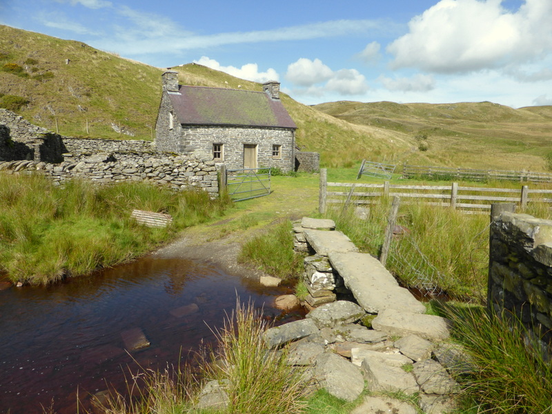 |
| Claerddu Bothy is in a wild location north of Teifi Pools. It is owned and well maintained by the Elan Valley Trust. Facilities include sleeping platforms, bottled gas cooking facilities, running water and a flush toilet. It does not need to be booked but dry matches are advisable and there is no guarantee of firewood. Photo 1 Photo 2 Photo 3 | |||
| Stage 11 - Claerddu Bothy to Ponterwyd |
| Name | Location | Grid Ref (approx) | Photo |
| Gelmast Farm /// drives. |
1.3 miles NNW of Cymystwyth - Directly on route - (Cicerone P137, A.J. Drake Map 28) | SN776756 |  |
| This remote farm is surrounded by forest in the hills 2.5 miles east of Devil's Bridge. This is the farm where Thomas Johnes (1748 - 1816), an MP, architect, farmer, printer and writer experimented with the breeding of livestock and developed new farming methods for crops. This greatly improved efficiency and led to present-day farming practices. He also grew trees on land that was unsuitable for crops. There is a notice board explaining this by the farm. | |||
| The Arch near Devil's Bridge /// suffix. |
On B4574 2 miles ESE of Devil's Bridge - Directly on route - (Cicerone P137, A.J. Drake Map 28) | SN765756 |  |
| The Arch was built to commemorate King George III's Jubilee in 1810 by Thomas Johnes owner of the Hafod Estate. The road used to run beneath the arch but now bypasses it. It has a picnic site with parking and toilets. Stay in Wales Entry | |||
| Vale of Rheidol Railway /// rich. |
Devil's Bridge - Directly on route - (Cicerone P139, A.J. Drake Map 28 & 29) | SN739769 |  |
| This narrow gauge railway was built in 1902 to carry lead ore, timber and passengers. It runs from Aberytwyth to Devil's Bridge through stunning scenery. The station at Devil's Bridge makes a good lunch stop and there is a tap with drinkable water on a nearby building. Railway website | |||
| Disused Mines near Pontbren Pwlca /// promise. |
Vale of Rheidol, Devil's Bridge - Directly on route - (Cicerone P139, A.J. Drake Map 29A) | SN729781 |  photo � John S Mason |
| The disused mine on the north side of the River Rheidol near the Pontbren Pwlca Bridge (this name is only marked on local maps not O.S. maps) on map 29A of the A.J. Drake guide is a former lode mine, a lead-zinc bearing mineral, but there was a lot of iron sulphide marcasite present which decayed into sulphuric acid. There are some interesting panels about the mining and the disaster caused in the late 1960s when one of the tunnels burst sending a cascade of acid down the side of the mountain, poisoning the fish in the Rheidol. Geology Wales Report | |||
| Stage 12 - Ponterwyd to Dylife |
| Name | Location | Grid Ref (approx) | Photo |
| Dyffryn Castell Hotel /// promise. |
A44 1.6 miles ENE of Ponterwyd - Directly on route - (Cicerone P143, A.J. Drake Map 29) | SN774817 |  |
| The Dyffryn Castell Hotel closed around 2008. Renovation work has was underway in 2010, but has been intermittent, and the hotel was was still closed in 2015. Please let us know if there is any update. E-mail to info@cambrianway.org.uk | |||
| Marker Stones on Plynlimon /// similar. |
Plynlimon and Pum Pumlumon Arwystli - Directly on route - (Cicerone P144, A.J. Drake Map 31) | SN800868 |  |
| There are seven slate marker stones on the higher ground over Plynlimon and Pen Pumlumon Arwystli. Most have the letters WWW 1865 and an upward pointing arrow, but inscriptions vary a little. The initials refer to William Watkins Wynn, who was a very rich landowner, owning vast areas of land in Wales, even extending across the border into Shropshire. It is, therefore, likely that they marked a boundary to some of his land. | |||
| The Star, Dylife /// cutback. |
Dylife Village - Directly on route - (Cicerone P151, A.J. Drake Map 31 & 32) | SN863941 |  |
| The Star, formerly The Star Inn, dates back to 1640, and is located in the remote village of Dylife, in an area of old lead mines. It changed ownership and underwent extensive renovation before reopening in 2015 as a health spa and B&B, but lost its regular trade and was then sold to new owners who reopened it as a traditional inn. This was running successfully until the new owners decided to close it during the Covid-19 pandemic and it is now a private house. This has been a sad loss for Cambrian Way walkers in a place where accommodation is scarce. | |||
| Stage 13 - Dylife to Dinas Mawddwy |
| Name | Location | Grid Ref (approx) | Photo |
| Another Tony Drake Waymark Post /// discussed. |
Coed Bryneinion 0.5 miles SE of Commins Coch - Directly on route - (Cicerone P155, A.J. Drake Map 32B) | SH849025 | |
| One of the few Cambrian Way waymark posts erected by Tony Drake was at this point in the forest where the route turns off to go down the hillside. In recent years felling operations have made the route easier to see. Its base is now rotted but it has been temporarily held upright with some stones. | |||
| Cemmaes Wind Farm /// evidence. |
2.5 miles NNE of Commins Coch - Directly on route - (Cicerone P159, A.J. Drake Map 33) | SH867064 |  |
| The Cambrian Way runs through the Wind Farm for about 1.5 miles and gives the opportunity to see, hear and feel the turbines at close quarters. It is an eerie sensation in mist when the whooshing of the blades is sensed before they loom into sight. Though they are fascinating in a way, the scenery of Mid Wales, in particular, is blighted by too many of them. Turbine Details | |||
| Buckley Arms Hotel /// roofer. |
Minllyn, near Dinas Mawddwy - beside A470 0.25 miles S of Cicerone route when visiting Dinas Mawddwy - Directly on old route (Cicerone P159, A.J. Drake Map 34A) | SH867064 |  |
| The Buckley Arms Hotel was built in 1873 and is reptedly the oldest reinforced concrete building in Europe and the second oldest concrete building in the World. Sir Edmund Buckley was quite a character and went bankrupt shortly after building the hotel. He was involved in selling shares in a gold mine (possibly this one) which did not have any gold. Hotel website | |||
| Pont Minllyn over River Dovey /// sized. |
Beside A470 0.4 miles S of Cicerone route when visiting Dinas Mawddwy - Close to old route (Cicerone P159, A.J. Drake Map 34A) | SH860139 |  |
| The bridge was buit in the early 17th Century at the expense of Dr John Davies, Rector of Mallwyd from 1604 to 1634. It is very close to the modern road bridge taking the A40 across the River Dovey. It is a Grade II Listed Building, being a good example of early bridge building. British Listed Buildings Entry | |||
| Stage 14 - Dinas Mawddwy to Bwlch Llyn Bach |
| Name | Location | Grid Ref (approx) | Photo |
| Red Dragon Mine, Dinas Mawddwy /// kicked. |
0.1 miles N of route at Bwlch Siglen (0.3 miles by path) - (Cicerone P169, A.J. Drake Map 34) | SH836139 | 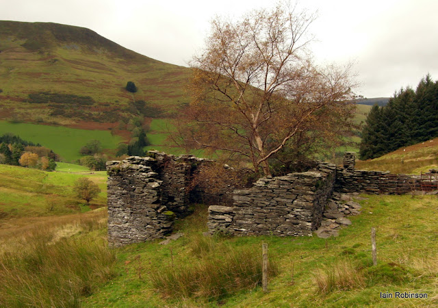 photo � Iain Robinson |
| The Red Dragon Mine started as a lead mine in 1852 but a "black mineral" (possibly manganese) was found in large quantities. Struggling for finance, the investors were tempted by suggestions of gold, and poured in a large amount of money to fund gold mining in 1854, only to find there was none and the mine was abandoned around 1856. This mine was mentioned in a previous Point of Interest as the venture that may have lost Sir Edmund Buckley a lot of money. Iain Robinson's Blog | |||
| Stage 15 - Bwlch Llyn Bach to Barmouth |
| Name | Location | Grid Ref (approx) | Photo |
| Cadair Idris Summit - 893m (2927 ft) /// trees. |
Directly on route - (Cicerone P174, A.J. Drake Map 36) | SH711131 |  |
| Whatever route is taken up Cadair Idris, there are spectacular views in clear conditions. Although it does not quite reach 3000 ft, the views are every bit as good as many that do. There is a Mountain Refuge Shelter just N of the summit if needed, but on a good day there is a fine lunch stop just down from the summit to the south, overlooking Llyn Cau. Wikipedia Entry | |||
| Llynau Cregennen (NT) /// pairings. |
Directly on route - (Cicerone P177, A.J. Drake Map 38) | SH659143 |  |
| The area around Llynau Cregennen, or Cregennan Lakes is owned by the National Trust and is one of the lesser known beauty spots in Wales. There are views of the lakes themselves, Cadair Idris and, a short way along the road going N, a view over Barmouth Bay. View from Above | |||
| Clapper Bridge above Arthog Waterfalls /// smarting. |
Directly on route - (Cicerone P177, A.J. Drake Map 38B) | SH650138 |  |
| The route from Llynnau Cregennan leads over this old Clapper Bridge crossing the River Arthog. These ancient bridges were made by placing slabs of stone across a river with stone piers beween each stone. In this case, only one slab was needed. The path then goes north and soon descends down the steep path through woodland following the long series of cateracts of Arthog Waterfalls, for about half a mile, before reaching the A493 road near Arthog. | |||
| Arthog Hall /// part. |
0.2 miles W of route - (Cicerone P176, A.J. Drake Map 38) | SH644144 |  photo � rightmove.co.uk |
| Arthog Hall is a Grade II Listed Building located in the woodland about 300 yards west of Arthog Waterfalls. It is a Country house in picturesque castellated style, built 1833 for Reginald Fourden and currently in private ownership. British Listed Buildings Entry | |||
| Barmouth Bridge /// deriving. |
Directly on route - (Cicerone P176, A.J. Drake Map 38) | SH620154 |  |
| Barmouth Bridge is a Mainly wooden viaduct with a steel Swing Bridge for the passage of boats. It opened in 1867 to carry a single track railway line across the Mawddach Estuary. It also caters for foot and cycle traffic for which a toll was charged until 2013. There is a fine view of Coes-faen Clock Tower from the bridge. Wikipedia Entry Swing Bridge and Harbour | |||
| Barmouth /// explained. |
Directly on route - Town Centre 0.5 miles - (Cicerone P182, A.J. Drake Map 39) | SH612158 |  |
| Barmouth is a popular holiday town with many facilities for food, shops and accommodation. There is a plaque on the wall of the Barmouth Rowing Club at the harbour commemorating Harold Lowe, 5th Officer on the Titanic famous for his rescues of passengers. Wikipedia Entry | |||
| Stage 16 - Barmouth to Cwm Bychan |
| Name | Location | Grid Ref (approx) | Photo |
| Cwm Bychan, Rhinog Mountains /// trophy. |
Directly on route - (Cicerone P188, A.J. Drake Map 40 & 41) | SH647316 |  |
| Though difficult in places, there is much spendid ridge walking in the Rhinog Mountains with many fine views of mountains and lakes. The point highlighted in Cym Bychan is the approximate spot where the front cover photo of the guidebook was taken, with Tony Drake as a younger man, climbing upwards. Wikipedia Entry | |||
| Stage 17 - Cwm Bychan to Maentwrog |
| Name | Location | Grid Ref (approx) | Photo |
| Llyn Trawsfynnydd /// corrode. |
Close to route - (Cicerone P202, A.J. Drake Map 41) | SH690360 |  |
| Llyn Trawsfynydd is a man-made reservoir created in the 1920s to supply water for Maentwrog Hydro-electric Power Station. In 1965 it also became the source of cooling water for the Trawsfynydd Nuclear Power Station, which was shut down in 1991 and is still being decommissioned. An interesting feature is the footbridge across the eastern end of the lake, which is used by the Trawsfynydd Variant of the Cambrian Way. Wikipedia Entry | |||
| Stage 18 - Maentwrog to Beddgelert |
| Name | Location | Grid Ref (approx) | Photo |
| Ffestiniog Railway, Dduallt Station /// oven. |
Directly on route - (Cicerone P207, A.J. Drake Map 43 & 43A) | SH679421 |  |
| An interesting feature of the Ffestiniog Railway at Dduallt is the loop in the track. When Llyn Tanygrisiau Reservoir was created, the disused railway line was flooded, so when restoration took place extra height had to be gained somewhere; hence the loop was built. Festrail website Wikipedia Entry Train Entering Loop Train Completing Loop | |||
| Llyn Stwlan Pumped Storage Reservoir /// lions. |
Close to route - (Cicerone P208, A.J. Drake Map 43 & 43B) | SH664444 |  |
| Llyn Stwlan is the upper reservoir of the Ffestiniog Pumped Storage Hydro-electic Power Station, the Tanygrisiau Reservoir being the lower one. At off-peak times water is pumped from the lower to upper reservoir and, when power is needed at peak times, the flow is reversed, about 72% of the power being regained. Providing power quickly at peak times is of very high value, so the wasted energy is well worth while. Tanygrisiau Power Station | |||
| Rhosydd Slate Quarry /// they. |
Directly on route - (Cicerone P213, A.J. Drake Map 43) | SH665462 |  |
| Quarrying for slate first started in the early 1830s, but there were many difficulties with working at about 1500 ft above sea level and with the transportation of the slate. Despite large sums of money being spent, it went into voluntary liquidation in 1873. It was re-opened by new owners and continued to be worked until 1930 when it became uneconomical and never properly restarted. Wikipedia Entry | |||
| Aberglaslyn Pass /// sketching. |
Directly on Main route - 1 mile S of Beddgelert - (Cicerone P215, A.J. Drake Map 44 & 44A) | SH595467 |  |
| The Pass of Aberglaslyn is a narrow gorge by the River Glaslyn, where the longest tunnels on the Welsh Highland Railway are to be found. This section of the railway was re-opened in 2009 when the line was extended down to Porthmadog after many years of disuse. The line runs by the left side of the river on the photograph before entering the tunnels. Wikipedia Entry Festrail Entry | |||
| Gelert's Grave, Beddgelert /// rivers. |
0.1 miles W of Main route - 0.3 miles S of Beddgelert - (Cicerone P215, A.J. Drake Map 44) | SH590477 |  |
| Beddgelert Means 'Grave of Gelert', the faithful dog that was, in the legend, slain by Prince Llywelyn when he thought it had killed his baby son, only to find the baby safe and sound near the body of a wolf that his dog had killed whilst protecting the child. Wikipedia Entry Gelert's Statue | |||
| Stage 19 - Beddgelert to Pen y Pass |
| Name | Location | Grid Ref (approx) | Photo |
| Sygun Copper Mine, Beddgelert /// foil. |
Close to Main route - 1.2 miles ENE of Beddgelert - (Cicerone P219, A.J. Drake Map 44) | SH605488 |  |
| Sygun Copper Mine is a Victorian copper mine that was closed in 1903, but was renovated and reopened by the Amies family as a tourist attraction in 1986, focusing on audio-visual tours of the underground workings. Wikipedia Entry Copper Mine website | |||
| Gladsone Rock, Snowdon /// duck. |
0.25 miles from Cicerone route, directly on A.J. Drake route - on Watkin Path up Snowdon - (Cicerone P220, A.J. Drake Map 45) | SH618523 |  photo � David Neale |
| Beside the Watkin Path in Cwm Llan on the ascent of Snowdon stands the Gladstone Rock inscribed with: 'Sep 13th 1892 Upon this rock the Right Honourable W.E. Gladstone M.P. when Prime Minister for the fourth time and 83 years old addressed the people of Eryri upon justice to Wales The multitude sang Cymric hymns and Land of my Fathers Publicly dedicated by Sir Edward and Lady Watkin June 1893.' Geotopai Entry | |||
| Snowdon Summit Visitor Centre /// rocky. |
Directly on Main route - (Cicerone P220, A.J. Drake Map 45) | SH609544 |  |
| In 2009, the new Snowdon Summit Visitor Centre (Hafod Eryri) was opened, with tourist information, caf� and gift shop as well as being the terminus of the Snowdon Mountain Railway. The futuristic building replaces the ramshackle buildings that were once called 'the highest slum in Britain' by Prince Charles. Snowdon Wikipedia Entry | |||
| Snowdon Pen y Pass Youth Hostel /// puzzle. |
Directly on Main route - 3 miles ENE of Snowdon Summit - (Cicerone P227, A.J. Drake Map 45) | SH647556 |  |
| As well as providing accommdation for walkers, the Snowdon Pen-y-Pass Youth Hostel benefitted from a bequest from Tony Drake, which helped towards the �1.3m Hostel Refurbishment. Facilities include: New caf� and bar open to the public, new games room and classroom, new self-catering kitchen facilities, public WCs and showers for day walkers. Snowdon Pen y Pass YHA Entry | |||
| Stage 20 - Pen y Pass to Llyn Ogwen |
| Name | Location | Grid Ref (approx) | Photo |
| Cantilever Stone, Glyder Fach /// scared. |
Close to Main route - Just E of Summit - (Cicerone P227, A.J. Drake Map 46) | SH657583 |  |
| Amongst the huge number of stones and boulders around the summit area of Glyder Fach is the Cantilever Stone balancing near its middle. Despite its precarious appearance it is quite stable with a few people standing on it. However, it has been seen and heard rocking when a group of five or six people jump up and down on it in unison. One Group Jumping | |||
| Stage 21 - Llyn Ogwen to Conwy |
| Name | Location | Grid Ref (approx) | Photo |
| Refuge Shelter on Foel Grach /// modules. |
Directly on route - 1 mile N of Carnedd Llewelyn - (Cicerone P233, A.J. Drake Map 47) | SH689659 |  |
| There is a Mountain Refuge Hut just north of Foel Grach for shelter if caught out in bad weather along this ridge, much of which is over 3000 ft above sea level. It nestles in the the mountainside just where the steep descent levels off and can easily be missed when looking straight ahead. | |||
| Carnedd Gwenllian (formerly Garnedd Uchaf) /// flat. |
Directly on route - (Cicerone P235, A.J. Drake Map 47) | SH687669 |  |
| In 2009, Garnedd Uchaf was renamed Carnedd Gwenllian in memory of Princess Gwenllian (1282-1337), only child of Llewelyn ap Gruffudd, the last native Prince of Wales, after whom Carnedd Llewelyn is named. She was confined in a priory in Lincolnshire after her father was killed in battle when she was an infant, and she never got to know her real identity. Photo taken from Carnedd Gwenllian with Carnedd Llewelyn far centre. Full History in Wikipedia | |||
| Shelter at Disused Quarry /// mercy. |
0.7 miles NE of Tal y Fan - Directly on route - (Cicerone P237, A.J. Drake Map 49A). | SH738733 |  |
| On the descent of Tal y Fan, the route passes this small, disused quarry. Entry from the top is fenced off because of the dangerous rock faces, but lower down there is access and a small roofed shelter. The entrance is very low, but there is somewhat more headroom inside. The quarry is possibly of medieval origin but closed down in 1914. | |||
| Maen Penddu /// vowel. |
0.9 miles NE of Tal y Fan - Directly on route - (Cicerone P237, A.J. Drake Map 49A) | SH739736 |  |
| Maen Penddu meaning the Black-headed Stone is in a prominent position where the slope levels off on the descent of Tal y Fan, below the old slate quarry. The shape and texture of the stone suggest it was brought from elsewhere and it is thought to date back to around 2000 BC. This Photo looks SW from Maen Penddu towards the quarry and Tal y Fan. Our Heritage website | |||
| Sychnant Pass Road /// directly. |
Directly on route - (Cicerone P238, A.J. Drake Map 49) | SH750770 |  |
| The Sychnant Pass is a deep cleft between Alltwen, and Maen Esgob. Around here, the hills run right up to the sea, so this was the only practical route for the old turnpike road to take going west from Conwy when it was built in 1772. However, the ascent was difficult for horse drawn vehicles, so in 1830 Thomas Telford built a road around the cliffs on the coast at Penmaen Bach. Wikipedia Entry historypoints.org Entry | |||
| Conwy Mountain Hill Fort /// bakers. | Directly on route - (Cicerone P238, A.J. Drake Map 49) | SH760778 |  |
| There are remains of an Iron Age Hill Fort around the summit of Conwy Mountain, with a number of hut circles around the area. It was called Castell Caer Seion (or Lleion) and excavations in the 1950s found pre-Roman coins and artefacts. There are notice boards explaining some of the history. Wikipedia Entry historypoints.org Entry | |||
| Conwy Castle, End of Cambrian Way /// safely. |
Directly on route - (Cicerone P238, A.J. Drake Map 49) | SH784774 |  |
| Conwy Castle was built by Edward I between 1283 and 1289 during his conquest of Wales. It is a World Heritage Site and is considered by UNESCO to be one of the finest examples of late 13th century and early 14th century military architecture in Europe. What finer place to end the Cambrian Way? Wikipedia Entry Cadw Entry | |||
Route of the Cambrian Way - Summits on or near Route
| Summits near Route - Mountains of 2000ft or over (610m) |
- 46 are on the Main Route, including ten that are over 3,000ft (914m).
- 5 are on Route Variants.
- 2 are on the High Level Option from Snowdon over the Crib Goch Ridge.
- 16 more that are close to the route have also been included.
- Several more at a slightly greater distance that have been omitted.
- A full list of the 190 mountain tops of Wales can be found on John and Anne Nuttall's website.
| Summit | Grid Ref / what3words | Height | Notes |
| Chwarel y Fan | SO258294 /// wove. |
2228ft (679m) | On Main Route |
| Twmpa (Lord Hereford's Knob) | SO225350 /// carpentry. |
2231ft (680m) | On Main Route |
| Rhos Dirion | SO211334 /// candle. |
2339ft (713m) | On Main Route |
| Waun Fach | SO215300 /// rosette. |
2661ft (811m) | On Main Route |
| Mynydd Llysiau | SO207279 /// beards. |
2175ft (663m) | On Main Route |
| Pen Twyn Glas | SO213257 /// richly. |
2119ft (646m) | On Main Route |
| Pen Allt-mawr | SO207243 /// surround. |
2359ft (719m) | On Main Route |
| Pen Cerrig-calch | SO217223 /// vacancies. |
2300ft (701m) | On Main Route |
| Waun Rydd | SO062206 /// callers. |
2523ft (769m) | 170m off Main Route, 6m Ascent |
| Bwlch y Ddwyallt | SO055203 /// giving. |
2474ft (754m) | On Talybont Variant |
| Fan y Big | SO036207 /// unpainted. |
2359ft (719m) | 520m off Main Route, 4m Ascent |
| Cribyn | SO024213 /// investor. |
2608ft (795m) | On Main Route |
| Pen y Fan | SO012216 /// humidity. |
2907ft (886m) | On Main Route |
| Corn Du | SO007213 /// stores. |
2864ft (873m) | On Main Route |
| Y Gyrn | SN989216 /// infringe. |
2031ft (619m) | 500m off Main Route, 26m Ascent |
| Fan Fawr | SN970193 /// calms. |
2408ft (734m) | 1020m off Main Route, 178m Ascent |
| Fan Nedd | SN913184 /// nightcap. |
2175ft (663m) | 970m off Main Route, 133m Ascent |
| Fan Fraith | SN887184 /// unsigned. |
2192ft (668m) | 680m off Main Route, 16m Ascent |
| Fan Gyhirych | SN881191 /// solder. |
2379ft (725m) | On Main Route |
| Fan Hir | SN831209 /// gullible. |
2497ft (761m) | On Ystradfellte Variant |
| Fan Brycheiniog | SN825218 /// coiling. |
2631ft (802m) | On Main Route |
| Picws Du | SN812219 /// daily. |
2457ft (749m) | On Cicerone Main Route, A.J. Drake Llanddeusant Variant |
| Waun Lefrith | SN798215 /// publish. |
2221ft (677m) | On Cicerone Main Route, A.J. Drake Llanddeusant Variant |
| Pumlumon Fawr | SN790870 /// cyber. |
2467ft (752m) | On Main Route |
| Pen Pumlumon Llygad-bychan | SN799871 /// removed. |
2385ft (727m) | On Main Route |
| Pen Pumlumon Arwystli | SN815877 /// tops. |
2431ft (741m) | On Main Route |
| Maesglase (Maen Du) | SH817150 /// foggy. |
2218ft (676m) | On Main Route |
| Cribin Fawr | SH795153 /// roost. |
2162ft (659m) | 260m off Main Route, 22m Ascent |
| Waun-oer | SH786148 /// silver. |
2198ft (670m) | On Main Route |
| Gau Graig | SH744141 /// reject. |
2241ft (683m) | 130m off Main Route, 2m Ascent |
| Mynydd Moel | SH727137 /// beauty. |
2831ft (863m) | On Main Route |
| Cadair Idris (Penygadair) | SH711130 /// captions. |
2930ft (893m) | On Main Route |
| Craig Cwm Amarch | SH711121 /// replays. |
2595ft (791m) | On Minffordd Variant |
| Cyfrwy | SH704133 /// patching. |
2661ft (811m) | 240m off Main Route, 47m Ascent |
| Tyrrau Mawr | SH677135 /// shoppers. |
2169ft (661m) | On Main Route |
| Craig-y-llyn | SH665119 /// envisage. |
2041ft (622m) | 700m off Main Route, 123m Ascent |
| Diffwys West Top | SH648229 /// dividers. |
2106ft (642m) | On Main Route |
| Diffwys | SH661234 /// splinters. |
2461ft (750m) | On Main Route |
| Crib-y-rhiw | SH663249 /// harmony. |
2198ft (670m) | On Main Route |
| Y Llethr | SH661258 /// trimmer. |
2480ft (756m) | On Main Route |
| Rhinog Fach | SH665270 /// spring. |
2336ft (712m) | On Main Route |
| Rhinog Fawr | SH657290 /// ultra. |
2363ft (720m) | On Main Route |
| Moel Ysgyfarnogod | SH658346 /// reflector. |
2044ft (623m) | On Main Route |
| Foel Penolau | SH661348 /// worth. |
2014ft (614m) | On Main Route |
| Moelwyn Bach | SH660437 /// nosedive. |
2329ft (710m) | 560m off Main Route, 118m Ascent |
| Craigysgafn | SH660443 /// pylons. |
2260ft (689m) | On Main Route |
| Moelwyn Mawr | SH658449 /// generated. |
2526ft (770m) | On Main Route |
| Moelwyn Mawr North Ridge Top | SH661453 /// paddocks. |
2119ft (646m) | 35m off Main Route, 1m Ascent |
| Moel-yr-hydd | SH672454 /// influence. |
2126ft (648m) | 690m off Main Route, 103m Ascent |
| Cnicht North Top | SH648468 /// hook. |
2251ft (686m) | On Main Route |
| Cnicht | SH645466 /// endings. |
2260ft (689m) | On Main Route |
| Yr Aran | SH604515 /// rationed. |
2451ft (747m) | 800m off Main Route, 220m Ascent |
| Snowdon | SH609544 /// remarked. |
3560ft (1085m) | On Main Route |
| Crib y Ddysgl (Garnedd Ugain) | SH611552 /// historic. |
3494ft (1065m) | On Crib Goch Alternative Route |
| Crib Goch | SH624552 /// devalued. |
3028ft (923m) | On Crib Goch Alternative Route |
| Glyder Fawr | SH642579 /// plod. |
3278ft (999m) | On Main Route |
| Castell y Gwynt | SH654581 /// term. |
3189ft (972m) | On Main Route |
| Glyder Fach | SH656583 /// trudges. |
3261ft (994m) | On Main Route |
| Y Foel Goch | SH678582 /// nicknames. |
2641ft (805m) | 1090m off Main Route, 63m Ascent |
| Tryfan | SH664594 /// splinters. |
3002ft (915m) | 670m off Main Route, 191m Ascent |
| Pen yr Ole Wen | SH656619 /// booth. |
3209ft (978m) | On Main Route |
| Carnedd Dafydd | SH663631 /// converged. |
3425ft (1044m) | On Main Route |
| Carnedd Llewelyn | SH684644 /// clasping. |
3491ft (1064m) | On Main Route |
| Foel Grach | SH689659 /// client. |
3202ft (976m) | On Main Route |
| Carnedd Uchaf (Carnedd Gwenllian) | SH687669 /// helpless. |
3038ft (926m) | On Main Route |
| Foel-fras | SH696682 /// noodle. |
3091ft (942m) | On Main Route |
| Drum | SH708696 /// named. |
2526ft (770m) | On Main Route |
| Carnedd y Ddelw | SH708705 /// terminal. |
2257ft (688m) | On Main Route |
| Tal y Fan | SH729727 /// bikes. |
2001ft (610m) | On Main Route |